Boulzicourt geodata
Boulzicourt (Grand Est) is a populated place; located in France in Europe/Paris (GMT+2) time zone. With population of 999 people, there are 8836 cities with bigger population in this country. Compared to other cities in France, 91.5% of cities are located further ↓South; 73.7% of cities are located further ←West and 58.3% of cities have lower elevation than Boulzicourt. Note1
Administrative division(s):
- Level 1: Grand Est
- Level 2: Ardennes
- Level 3: Arrondissement de Charleville-Mézières
- Level 4: Boulzicourt


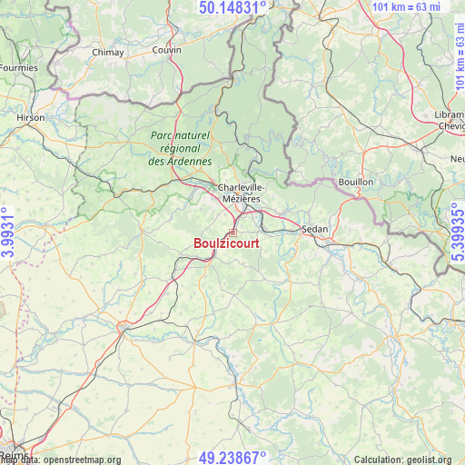
Boulzicourt GPS coordinates[2]
49° 41' 44.232" North, 4° 41' 46.428" East
| Map corner | latitude | longitude |
|---|---|---|
| Upper-left | 50.14831°, | 3.9931° |
| Center: | 49.69562°, | 4.69623° |
| Lower-right: | 49.23867°, | 5.39935° |
| Map W x H: | 101.1×101.1 km | = 62.8×62.8mi |
| max Lat: | 51.07786° ⇑8.5% North |
| Boulzicourt: | 49.69562° |
| min Lat: | ⇓91.5% South 41.3874° |
| min Long | Boulzicourt | max Long |
| -5.08615° | 4.69623° | 9.52242° |
| W 73.7%⇐ | ⇒26.3% E |
Elevation
Elevation of Boulzicourt is 162 m = 531 ft, and this is 31.7 m = 104 ft below average elevation for this country.
| Max E: |
2333 m = 7654 ft | 41.7% |
| Avg. | 193.7 m = 635 ft | |
| Boulzicourt | 162 m = 531 ft | |
Min E: |
-1 m = -3 ft | 58.3% |
See also: France elevation on elevation.city.
Geographical zone
Boulzicourt is located in North temperate zone (between Tropic of Cancer and the Arctic Circle). Distance of this North polar circle is 1875.5 km =1165.4 mi to North.| Distance of | km | miles | from Boulzicourt |
|---|---|---|---|
| North Pole | 4481.4 | 2784.6 | to North |
| Arctic Circle | 1875.5 | 1165.4 | to North |
| Tropic Cancer | 2919.7 | 1814.2 | to South |
| Equator | 5525.6 | 3433.4 | to South |


Nearby cities:
15 places around Boulzicourt: (largest is in red/bold)
• Chalandry-Elaire
4.5 km =2.8 mi,  58°
58°
• Charleville-Mézières
8.4 km =5.2 mi,  14°
14°
• Dom-le-Mesnil
7.7 km =4.8 mi,  94°
94°
• Flize
5.4 km =3.4 mi, 86°
• La Francheville
3.9 km =2.4 mi,  17°
17°
• Les Ayvelles
5.3 km =3.3 mi, 56°
• Lumes
7.8 km =4.8 mi, 56°
• Montcy-Notre-Dame
9.4 km =5.8 mi, 20°
• Nouvion-sur-Meuse
7.2 km =4.5 mi, 86°
• Poix-Terron
6.4 km =4 mi,  218°
218°
• Prix-lès-Mézières
6.7 km =4.2 mi,  356°
356°
• Saint-Laurent
9.4 km =5.8 mi,  35°
35°
• Sapogne-et-Feuchères
8.3 km =5.2 mi,  118°
118°
• Villers-Semeuse
6.3 km =3.9 mi, 35°
• Warcq
8.9 km =5.5 mi,  353°
353°
Sources, notices
• [Note1] Compared only with cities in France existing in our database
• [Src1] Map data: © OpenStreetMap contributors (CC-BY-SA)
• [Src2] Other city data from geonames.org with taken over terms of usage.
• [Src3] Geographical zone / Annual Mean Temperature by Robert A. Rohde @ Wikipedia
