Bordeaux geodata
Bordeaux (Nouvelle-Aquitaine) is a seat of a first-order administrative division; located in France in Europe/Paris (GMT+2) time zone. With population of 231,844 people, there are 8 cities with bigger population in this country. Compared to other cities in France, 81% of cities are located further ↑North; 84.3% of cities are located further →East and 93.9% of cities have higher elevation than Bordeaux. Note1
Administrative division(s):
- Level 1: Nouvelle-Aquitaine
- Level 2: Gironde
- Level 3: Arrondissement de Bordeaux
- Level 4: Bordeaux


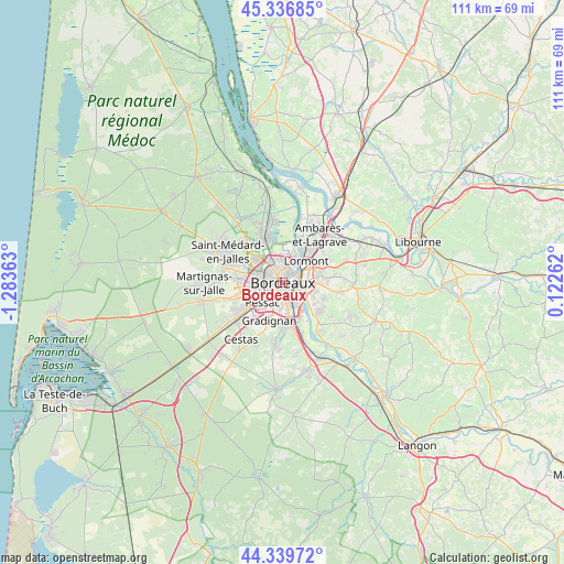
Bordeaux GPS coordinates[2]
44° 50' 25.584" North, 0° 34' 49.8" West
| Map corner | latitude | longitude |
|---|---|---|
| Upper-left | 45.33685°, | -1.28363° |
| Center: | 44.84044°, | -0.5805° |
| Lower-right: | 44.33972°, | 0.12262° |
| Map W x H: | 110.9×110.9 km | = 68.9×68.9mi |
| max Lat: | 51.07786° ⇑81% North |
| Bordeaux: | 44.84044° |
| min Lat: | ⇓19% South 41.3874° |
| min Long | Bordeaux | max Long |
| -5.08615° | -0.5805° | 9.52242° |
| W 15.7%⇐ | ⇒84.3% E |
Elevation
Elevation of Bordeaux is 20 m = 66 ft, and this is 173.7 m = 570 ft below average elevation for this country.
| Max E: |
2333 m = 7654 ft | 93.9% |
| Avg. | 193.7 m = 635 ft | |
| Bordeaux | 20 m = 66 ft | |
Min E: |
-1 m = -3 ft | 6.1% |
See also: Bordeaux elevation on elevation.city.
Geographical zone
Bordeaux is located in North temperate zone (between Tropic of Cancer and the Arctic Circle). Distance of this Northern Tropic circle is 2379.9 km =1478.8 mi to South.| Distance of | km | miles | from Bordeaux |
|---|---|---|---|
| North Pole | 5021.3 | 3120.1 | to North |
| Arctic Circle | 2415.4 | 1500.9 | to North |
| Tropic Cancer | 2379.9 | 1478.8 | to South |
| Equator | 4985.8 | 3098 | to South |


Nearby cities:
15 places around Bordeaux: (largest is in red/bold)
• Artigues-près-Bordeaux
5.1 km =3.2 mi,  78°
78°
• Bassens
8.5 km =5.3 mi,  36°
36°
• Bouliac
6.7 km =4.2 mi,  112°
112°
• Bruges
5 km =3.1 mi,  330°
330°
• Bègles
4.4 km =2.7 mi,  144°
144°
• Cenon
5.2 km =3.2 mi,  70°
70°
• Eysines
7.1 km =4.4 mi,  312°
312°
• Floirac
5.3 km =3.3 mi,  99°
99°
• Gradignan
8 km =5 mi,  199°
199°
• Le Bouscat
3 km =1.9 mi,  339°
339°
• Lormont
6.3 km =3.9 mi,  52°
52°
• Mérignac
4.3 km =2.7 mi,  258°
258°
• Pessac
5.9 km =3.7 mi,  234°
234°
• Talence
4.1 km =2.5 mi, 196°
• Villenave-d’Ornon
8 km =5 mi,  159°
159°
Sources, notices
• [Note1] Compared only with cities in France existing in our database
• [Src1] Map data: © OpenStreetMap contributors (CC-BY-SA)
• [Src2] Other city data from geonames.org with taken over terms of usage.
• [Src3] Geographical zone / Annual Mean Temperature by Robert A. Rohde @ Wikipedia
