Lormont geodata
Lormont (Nouvelle-Aquitaine) is a populated place; located in France in Europe/Paris (GMT+2) time zone. With population of 22,636 people, there are 396 cities with bigger population in this country. Compared to other cities in France, 80.7% of cities are located further ↑North; 83.6% of cities are located further →East and 83.1% of cities have higher elevation than Lormont. Note1
Administrative division(s):
- Level 1: Nouvelle-Aquitaine
- Level 2: Gironde
- Level 3: Arrondissement de Bordeaux
- Level 4: Lormont


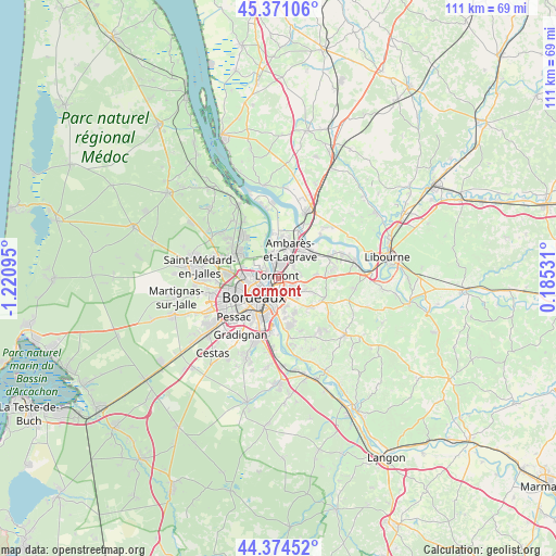
Lormont GPS coordinates[2]
44° 52' 29.82" North, 0° 31' 4.152" West
| Map corner | latitude | longitude |
|---|---|---|
| Upper-left | 45.37106°, | -1.22095° |
| Center: | 44.87495°, | -0.51782° |
| Lower-right: | 44.37452°, | 0.18531° |
| Map W x H: | 110.8×110.8 km | = 68.8×68.8mi |
| max Lat: | 51.07786° ⇑80.7% North |
| Lormont: | 44.87495° |
| min Lat: | ⇓19.3% South 41.3874° |
| min Long | Lormont | max Long |
| -5.08615° | -0.51782° | 9.52242° |
| W 16.4%⇐ | ⇒83.6% E |
Elevation
Elevation of Lormont is 47 m = 154 ft, and this is 146.7 m = 481 ft below average elevation for this country.
| Max E: |
2333 m = 7654 ft | 83.1% |
| Avg. | 193.7 m = 635 ft | |
| Lormont | 47 m = 154 ft | |
Min E: |
-1 m = -3 ft | 16.9% |
See also: France elevation on elevation.city.
Geographical zone
Lormont is located in North temperate zone (between Tropic of Cancer and the Arctic Circle). Distance of this Northern Tropic circle is 2383.7 km =1481.2 mi to South.| Distance of | km | miles | from Lormont |
|---|---|---|---|
| North Pole | 5017.4 | 3117.7 | to North |
| Arctic Circle | 2411.5 | 1498.4 | to North |
| Tropic Cancer | 2383.7 | 1481.2 | to South |
| Equator | 4989.6 | 3100.4 | to South |


Nearby cities:
15 places around Lormont: (largest is in red/bold)
• Ambarès-et-Lagrave
5.4 km =3.4 mi,  30°
30°
• Artigues-près-Bordeaux
2.8 km =1.7 mi,  178°
178°
• Bassens
3 km =1.9 mi,  2°
2°
• Bordeaux
6.3 km =3.9 mi,  232°
232°
• Bouliac
6.5 km =4 mi,  169°
169°
• Bruges
7.5 km =4.7 mi,  274°
274°
• Carbon-Blanc
2.7 km =1.7 mi, 28°
• Cenon
2.1 km =1.3 mi, 181°
• Floirac
4.7 km =2.9 mi, 176°
• Le Bouscat
6.1 km =3.8 mi,  260°
260°
• Montussan
7.6 km =4.7 mi,  85°
85°
• Pompignac
6.9 km =4.3 mi,  112°
112°
• Sainte-Eulalie
4.9 km =3 mi,  44°
44°
• Tresses
5.3 km =3.3 mi,  124°
124°
• Yvrac
4.7 km =2.9 mi, 86°
Sources, notices
• [Note1] Compared only with cities in France existing in our database
• [Src1] Map data: © OpenStreetMap contributors (CC-BY-SA)
• [Src2] Other city data from geonames.org with taken over terms of usage.
• [Src3] Geographical zone / Annual Mean Temperature by Robert A. Rohde @ Wikipedia
