Béguey geodata
Béguey (Nouvelle-Aquitaine) is a populated place; located in France in Europe/Paris (GMT+2) time zone. With population of 996 people, there are 8863 cities with bigger population in this country. Compared to other cities in France, 82.5% of cities are located further ↑North; 81.1% of cities are located further →East and 94.7% of cities have higher elevation than Béguey. Note1
Administrative division(s):
- Level 1: Nouvelle-Aquitaine
- Level 2: Gironde
- Level 3: Arrondissement de Langon
- Level 4: Béguey


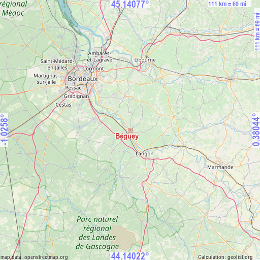
Béguey GPS coordinates[2]
44° 38' 33.54" North, 0° 19' 21.648" West
| Map corner | latitude | longitude |
|---|---|---|
| Upper-left | 45.14077°, | -1.0258° |
| Center: | 44.64265°, | -0.32268° |
| Lower-right: | 44.14022°, | 0.38044° |
| Map W x H: | 111.3×111.2 km | = 69.2×69.1mi |
| max Lat: | 51.07786° ⇑82.5% North |
| Béguey: | 44.64265° |
| min Lat: | ⇓17.5% South 41.3874° |
| min Long | Béguey | max Long |
| -5.08615° | -0.32268° | 9.52242° |
| W 18.9%⇐ | ⇒81.1% E |
Elevation
Elevation of Béguey is 18 m = 59 ft, and this is 175.7 m = 576 ft below average elevation for this country.
| Max E: |
2333 m = 7654 ft | 94.7% |
| Avg. | 193.7 m = 635 ft | |
| Béguey | 18 m = 59 ft | |
Min E: |
-1 m = -3 ft | 5.3% |
See also: France elevation on elevation.city.
Geographical zone
Béguey is located in North temperate zone (between Tropic of Cancer and the Arctic Circle). Distance of this Northern Tropic circle is 2357.9 km =1465.1 mi to South.| Distance of | km | miles | from Béguey |
|---|---|---|---|
| North Pole | 5043.3 | 3133.8 | to North |
| Arctic Circle | 2437.4 | 1514.5 | to North |
| Tropic Cancer | 2357.9 | 1465.1 | to South |
| Equator | 4963.8 | 3084.4 | to South |


Nearby cities:
15 places around Béguey: (largest is in red/bold)
• Arbanats
6.8 km =4.2 mi,  302°
302°
• Barsac
4 km =2.5 mi,  171°
171°
• Cadillac
0.8 km =0.5 mi,  147°
147°
• Capian
7.6 km =4.7 mi,  355°
355°
• Cérons
1.2 km =0.7 mi,  228°
228°
• Illats
6.4 km =4 mi,  217°
217°
• Lestiac-sur-Garonne
7 km =4.3 mi,  324°
324°
• Loupiac
3.4 km =2.1 mi, 148°
• Paillet
5.8 km =3.6 mi, 324°
• Podensac
2.7 km =1.7 mi,  288°
288°
• Preignac
6.9 km =4.3 mi,  160°
160°
• Rions
3.3 km =2.1 mi, 316°
• Sainte-Croix-du-Mont
6.8 km =4.2 mi,  143°
143°
• Verdelais
8.3 km =5.2 mi, 136°
• Virelade
5.2 km =3.2 mi, 299°
Sources, notices
• [Note1] Compared only with cities in France existing in our database
• [Src1] Map data: © OpenStreetMap contributors (CC-BY-SA)
• [Src2] Other city data from geonames.org with taken over terms of usage.
• [Src3] Geographical zone / Annual Mean Temperature by Robert A. Rohde @ Wikipedia
