Barberaz geodata
Barberaz (Auvergne-Rhône-Alpes) is a populated place; located in France in Europe/Paris (GMT+2) time zone. With population of 5,059 people, there are 1950 cities with bigger population in this country. Compared to other cities in France, 73.2% of cities are located further ↑North; 86.4% of cities are located further ←West and 82.3% of cities have lower elevation than Barberaz. Note1
Administrative division(s):
- Level 1: Auvergne-Rhône-Alpes
- Level 2: Savoie
- Level 3: Arrondissement de Chambéry
- Level 4: Barberaz


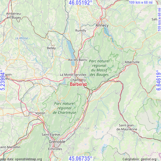
Barberaz GPS coordinates[2]
45° 33' 42.444" North, 5° 56' 35.016" East
| Map corner | latitude | longitude |
|---|---|---|
| Upper-left | 46.05192°, | 5.23994° |
| Center: | 45.56179°, | 5.94306° |
| Lower-right: | 45.06735°, | 6.64619° |
| Map W x H: | 109.5×109.5 km | = 68×68mi |
| max Lat: | 51.07786° ⇑73.2% North |
| Barberaz: | 45.56179° |
| min Lat: | ⇓26.8% South 41.3874° |
| min Long | Barberaz | max Long |
| -5.08615° | 5.94306° | 9.52242° |
| W 86.4%⇐ | ⇒13.6% E |
Elevation
Elevation of Barberaz is 313 m = 1027 ft, and this is 119.3 m = 391 ft above average elevation for this country.
| Max E: |
2333 m = 7654 ft | 17.7% |
| Barberaz | 313 m 1027 ft | |
| Avg. | 193.7 m = 635 ft | |
Min E: |
-1 m = -3 ft | 82.3% |
See also: France elevation on elevation.city.
Geographical zone
Barberaz is located in North temperate zone (between Tropic of Cancer and the Arctic Circle). Distance of this North polar circle is 2335.2 km =1451 mi to North.| Distance of | km | miles | from Barberaz |
|---|---|---|---|
| North Pole | 4941.1 | 3070.3 | to North |
| Arctic Circle | 2335.2 | 1451 | to North |
| Tropic Cancer | 2460.1 | 1528.6 | to South |
| Equator | 5066 | 3147.9 | to South |


Nearby cities:
15 places around Barberaz: (largest is in red/bold)
• Barby
2.9 km =1.8 mi,  76°
76°
• Bassens
1.6 km =1 mi,  348°
348°
• Challes-les-Eaux
3.4 km =2.1 mi,  119°
119°
• Chambéry
1.8 km =1.1 mi,  286°
286°
• Cognin
4.1 km =2.5 mi,  266°
266°
• Curienne
5.1 km =3.2 mi, 83°
• Jacob-Bellecombette
2.2 km =1.4 mi,  258°
258°
• La Ravoire
1.2 km =0.7 mi,  85°
85°
• Montagnole
3.3 km =2.1 mi,  225°
225°
• Saint-Alban-Leysse
2.5 km =1.6 mi,  12°
12°
• Saint-Baldoph
3.5 km =2.2 mi,  168°
168°
• Saint-Cassin
4.8 km =3 mi, 231°
• Saint-Jeoire-Prieuré
5.1 km =3.2 mi,  134°
134°
• Sonnaz
6.6 km =4.1 mi,  340°
340°
• Vimines
6.3 km =3.9 mi,  254°
254°
Sources, notices
• [Note1] Compared only with cities in France existing in our database
• [Src1] Map data: © OpenStreetMap contributors (CC-BY-SA)
• [Src2] Other city data from geonames.org with taken over terms of usage.
• [Src3] Geographical zone / Annual Mean Temperature by Robert A. Rohde @ Wikipedia
