Montagnole geodata
Montagnole (Auvergne-Rhône-Alpes) is a populated place; located in France in Europe/Paris (GMT+2) time zone. With population of 723 people, there are 11495 cities with bigger population in this country. Compared to other cities in France, 73.6% of cities are located further ↑North; 86.1% of cities are located further ←West and 93.7% of cities have lower elevation than Montagnole. Note1
Administrative division(s):
- Level 1: Auvergne-Rhône-Alpes
- Level 2: Savoie
- Level 3: Arrondissement de Chambéry
- Level 4: Montagnole


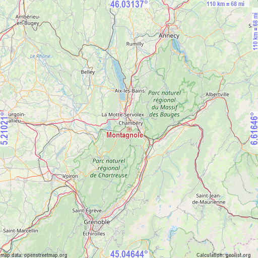
Montagnole GPS coordinates[2]
45° 32' 27.816" North, 5° 54' 47.988" East
| Map corner | latitude | longitude |
|---|---|---|
| Upper-left | 46.03137°, | 5.21021° |
| Center: | 45.54106°, | 5.91333° |
| Lower-right: | 45.04644°, | 6.61646° |
| Map W x H: | 109.5×109.5 km | = 68×68mi |
| max Lat: | 51.07786° ⇑73.6% North |
| Montagnole: | 45.54106° |
| min Lat: | ⇓26.4% South 41.3874° |
| min Long | Montagnole | max Long |
| -5.08615° | 5.91333° | 9.52242° |
| W 86.1%⇐ | ⇒13.9% E |
Elevation
Elevation of Montagnole is 529 m = 1736 ft, and this is 335.3 m = 1100 ft above average elevation for this country.
| Max E: |
2333 m = 7654 ft | 6.3% |
| Montagnole | 529 m 1736 ft | |
| Avg. | 193.7 m = 635 ft | |
Min E: |
-1 m = -3 ft | 93.7% |
See also: France elevation on elevation.city.
Geographical zone
Montagnole is located in North temperate zone (between Tropic of Cancer and the Arctic Circle). Distance of this North polar circle is 2337.5 km =1452.5 mi to North.| Distance of | km | miles | from Montagnole |
|---|---|---|---|
| North Pole | 4943.4 | 3071.7 | to North |
| Arctic Circle | 2337.5 | 1452.5 | to North |
| Tropic Cancer | 2457.8 | 1527.2 | to South |
| Equator | 5063.7 | 3146.4 | to South |


Nearby cities:
15 places around Montagnole: (largest is in red/bold)
• Apremont
5.4 km =3.4 mi,  147°
147°
• Barberaz
3.3 km =2.1 mi,  45°
45°
• Barby
6 km =3.7 mi,  59°
59°
• Bassens
4.3 km =2.7 mi,  27°
27°
• Challes-les-Eaux
5.3 km =3.3 mi,  83°
83°
• Chambéry
2.9 km =1.8 mi,  11°
11°
• Cognin
2.7 km =1.7 mi,  319°
319°
• Jacob-Bellecombette
1.8 km =1.1 mi,  3°
3°
• La Ravoire
4.2 km =2.6 mi, 55°
• Saint-Alban-Leysse
5.5 km =3.4 mi, 31°
• Saint-Baldoph
3.2 km =2 mi,  109°
109°
• Saint-Cassin
1.6 km =1 mi,  245°
245°
• Saint-Jeoire-Prieuré
6.1 km =3.8 mi,  102°
102°
• Saint-Sulpice
6 km =3.7 mi,  299°
299°
• Vimines
3.8 km =2.4 mi,  279°
279°
Sources, notices
• [Note1] Compared only with cities in France existing in our database
• [Src1] Map data: © OpenStreetMap contributors (CC-BY-SA)
• [Src2] Other city data from geonames.org with taken over terms of usage.
• [Src3] Geographical zone / Annual Mean Temperature by Robert A. Rohde @ Wikipedia
