Baigts-de-Béarn geodata
Baigts-de-Béarn (Nouvelle-Aquitaine) is a populated place; located in France in Europe/Paris (GMT+2) time zone. With population of 781 people, there are 10811 cities with bigger population in this country. Compared to other cities in France, 92.9% of cities are located further ↑North; 86.8% of cities are located further →East and 79.8% of cities have higher elevation than Baigts-de-Béarn. Note1
Administrative division(s):
- Level 1: Nouvelle-Aquitaine
- Level 2: Département des Pyrénées-Atlantiques
- Level 3: Arrondissement de Pau
- Level 4: Baigts-de-Béarn


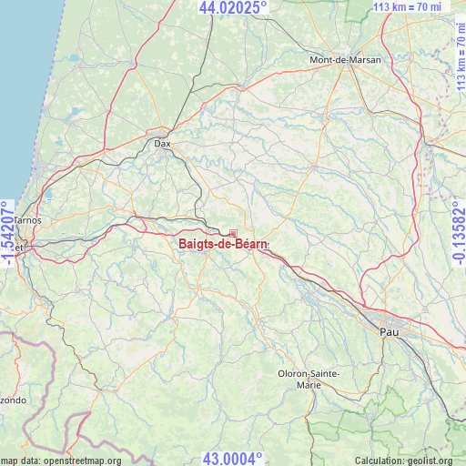
Baigts-de-Béarn GPS coordinates[2]
43° 30' 44.928" North, 0° 50' 20.184" West
| Map corner | latitude | longitude |
|---|---|---|
| Upper-left | 44.02025°, | -1.54207° |
| Center: | 43.51248°, | -0.83894° |
| Lower-right: | 43.0004°, | -0.13582° |
| Map W x H: | 113.4×113.4 km | = 70.5×70.5mi |
| max Lat: | 51.07786° ⇑92.9% North |
| Baigts-de-Béarn: | 43.51248° |
| min Lat: | ⇓7.1% South 41.3874° |
| min Long | Baigts-de-Béar | max Long |
| -5.08615° | -0.83894° | 9.52242° |
| W 13.2%⇐ | ⇒86.8% E |
Elevation
Elevation of Baigts-de-Béarn is 55 m = 180 ft, and this is 138.7 m = 455 ft below average elevation for this country.
| Max E: |
2333 m = 7654 ft | 79.8% |
| Avg. | 193.7 m = 635 ft | |
| Baigts-de-Béarn | 55 m = 180 ft | |
Min E: |
-1 m = -3 ft | 20.2% |
See also: France elevation on elevation.city.
Geographical zone
Baigts-de-Béarn is located in North temperate zone (between Tropic of Cancer and the Arctic Circle). Distance of this Northern Tropic circle is 2232.2 km =1387 mi to South.| Distance of | km | miles | from Baigts-de-Béarn |
|---|---|---|---|
| North Pole | 5168.9 | 3211.8 | to North |
| Arctic Circle | 2563 | 1592.6 | to North |
| Tropic Cancer | 2232.2 | 1387 | to South |
| Equator | 4838.1 | 3006.3 | to South |


Nearby cities:
15 places around Baigts-de-Béarn: (largest is in red/bold)
• Amou
11.6 km =7.2 mi,  39°
39°
• Bellocq
6.3 km =3.9 mi,  274°
274°
• Biron
9.9 km =6.2 mi,  124°
124°
• Bonnut
7.2 km =4.5 mi,  54°
54°
• Bérenx
1.6 km =1 mi,  212°
212°
• Castétis
11.1 km =6.9 mi, 117°
• Estibeaux
11.2 km =7 mi,  330°
330°
• Habas
9.9 km =6.2 mi,  312°
312°
• Labatut
12.4 km =7.7 mi,  289°
289°
• Orthez
6 km =3.7 mi, 116°
• Pomarez
13.1 km =8.1 mi,  3°
3°
• Puyoô
6.1 km =3.8 mi,  283°
283°
• Salies-de-Béarn
8.1 km =5 mi,  238°
238°
• Sallespisse
10.1 km =6.3 mi,  76°
76°
• Tilh
7 km =4.3 mi, 1°
Sources, notices
• [Note1] Compared only with cities in France existing in our database
• [Src1] Map data: © OpenStreetMap contributors (CC-BY-SA)
• [Src2] Other city data from geonames.org with taken over terms of usage.
• [Src3] Geographical zone / Annual Mean Temperature by Robert A. Rohde @ Wikipedia
