Habas geodata
Habas (Nouvelle-Aquitaine) is a populated place; located in France in Europe/Paris (GMT+2) time zone. With population of 1,470 people, there are 6296 cities with bigger population in this country. Compared to other cities in France, 92.2% of cities are located further ↑North; 87.6% of cities are located further →East and 57.3% of cities have higher elevation than Habas. Note1
Administrative division(s):
- Level 1: Nouvelle-Aquitaine
- Level 2: Landes
- Level 3: Arrondissement de Dax
- Level 4: Habas


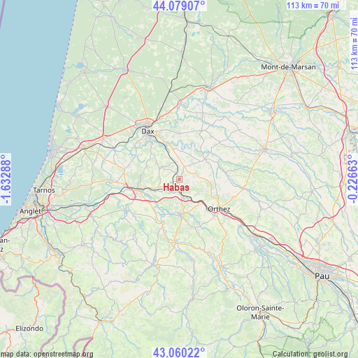
Habas GPS coordinates[2]
43° 34' 18.48" North, 0° 55' 47.136" West
| Map corner | latitude | longitude |
|---|---|---|
| Upper-left | 44.07907°, | -1.63288° |
| Center: | 43.5718°, | -0.92976° |
| Lower-right: | 43.06022°, | -0.22663° |
| Map W x H: | 113.3×113.3 km | = 70.4×70.4mi |
| max Lat: | 51.07786° ⇑92.2% North |
| Habas: | 43.5718° |
| min Lat: | ⇓7.8% South 41.3874° |
| min Long | Habas | max Long |
| -5.08615° | -0.92976° | 9.52242° |
| W 12.4%⇐ | ⇒87.6% E |
Elevation
Elevation of Habas is 110 m = 361 ft, and this is 83.7 m = 275 ft below average elevation for this country.
| Max E: |
2333 m = 7654 ft | 57.3% |
| Avg. | 193.7 m = 635 ft | |
| Habas | 110 m = 361 ft | |
Min E: |
-1 m = -3 ft | 42.7% |
See also: France elevation on elevation.city.
Geographical zone
Habas is located in North temperate zone (between Tropic of Cancer and the Arctic Circle). Distance of this Northern Tropic circle is 2238.8 km =1391.1 mi to South.| Distance of | km | miles | from Habas |
|---|---|---|---|
| North Pole | 5162.3 | 3207.7 | to North |
| Arctic Circle | 2556.4 | 1588.5 | to North |
| Tropic Cancer | 2238.8 | 1391.1 | to South |
| Equator | 4844.7 | 3010.4 | to South |


Nearby cities:
15 places around Habas: (largest is in red/bold)
• Baigts-de-Béarn
9.9 km =6.2 mi,  132°
132°
• Bellocq
6.2 km =3.9 mi,  170°
170°
• Bérenx
10.3 km =6.4 mi,  141°
141°
• Carresse-Cassaber
11.4 km =7.1 mi,  209°
209°
• Cauneille
10.9 km =6.8 mi,  255°
255°
• Clermont
8.9 km =5.5 mi,  6°
6°
• Estibeaux
3.7 km =2.3 mi,  29°
29°
• Labatut
5 km =3.1 mi,  240°
240°
• Mimbaste
9.3 km =5.8 mi,  337°
337°
• Misson
3.3 km =2.1 mi,  313°
313°
• Pomarez
10.3 km =6.4 mi,  51°
51°
• Pouillon
6.7 km =4.2 mi,  303°
303°
• Puyoô
5.4 km =3.4 mi, 165°
• Salies-de-Béarn
10.9 km =6.8 mi,  177°
177°
• Tilh
7.5 km =4.7 mi,  86°
86°
Sources, notices
• [Note1] Compared only with cities in France existing in our database
• [Src1] Map data: © OpenStreetMap contributors (CC-BY-SA)
• [Src2] Other city data from geonames.org with taken over terms of usage.
• [Src3] Geographical zone / Annual Mean Temperature by Robert A. Rohde @ Wikipedia
