Audierne geodata
Audierne (Brittany) is a populated place; located in France in Europe/Paris (GMT+2) time zone. With population of 2,601 people, there are 3749 cities with bigger population in this country. Compared to other cities in France, 59.5% of cities are located further ↓South; 99.8% of cities are located further →East and 96.7% of cities have higher elevation than Audierne. Note1
Administrative division(s):
- Level 1: Brittany
- Level 2: Département du Finistère
- Level 3: Arrondissement de Quimper
- Level 4: Audierne


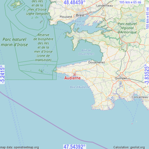
Audierne GPS coordinates[2]
48° 0' 59.04" North, 4° 32' 18.168" West
| Map corner | latitude | longitude |
|---|---|---|
| Upper-left | 48.48459°, | -5.2415° |
| Center: | 48.0164°, | -4.53838° |
| Lower-right: | 47.54392°, | -3.83525° |
| Map W x H: | 104.6×104.6 km | = 65×65mi |
| max Lat: | 51.07786° ⇑40.5% North |
| Audierne: | 48.0164° |
| min Lat: | ⇓59.5% South 41.3874° |
| min Long | Audierne | max Long |
| -5.08615° | -4.53838° | 9.52242° |
| W 0.2%⇐ | ⇒99.8% E |
Elevation
Elevation of Audierne is 12 m = 39 ft, and this is 181.7 m = 596 ft below average elevation for this country.
| Max E: |
2333 m = 7654 ft | 96.7% |
| Avg. | 193.7 m = 635 ft | |
| Audierne | 12 m = 39 ft | |
Min E: |
-1 m = -3 ft | 3.3% |
See also: France elevation on elevation.city.
Geographical zone
Audierne is located in North temperate zone (between Tropic of Cancer and the Arctic Circle). Distance of this North polar circle is 2062.3 km =1281.5 mi to North.| Distance of | km | miles | from Audierne |
|---|---|---|---|
| North Pole | 4668.1 | 2900.6 | to North |
| Arctic Circle | 2062.3 | 1281.5 | to North |
| Tropic Cancer | 2733 | 1698.2 | to South |
| Equator | 5338.9 | 3317.4 | to South |


Nearby cities:
15 places around Audierne: (largest is in red/bold)
• Beuzec-Cap-Sizun
6.9 km =4.3 mi,  16°
16°
• Cléden-Cap-Sizun
8.8 km =5.5 mi,  293°
293°
• Confort-Meilars
8.7 km =5.4 mi,  64°
64°
• Esquibien
2 km =1.2 mi,  299°
299°
• Landudec
15.1 km =9.4 mi,  96°
96°
• Mahalon
7.9 km =4.9 mi,  75°
75°
• Plogoff
9.8 km =6.1 mi,  283°
283°
• Plouhinec
4.1 km =2.5 mi,  89°
89°
• Plovan
16.9 km =10.5 mi,  130°
130°
• Plozévet
9.8 km =6.1 mi,  112°
112°
• Pont-Croix
4.7 km =2.9 mi,  54°
54°
• Pouldergat
15.7 km =9.8 mi, 76°
• Pouldreuzic
14.8 km =9.2 mi,  120°
120°
• Poullan-sur-Mer
11.7 km =7.3 mi, 50°
• Primelin
5.4 km =3.4 mi, 283°
Sources, notices
• [Note1] Compared only with cities in France existing in our database
• [Src1] Map data: © OpenStreetMap contributors (CC-BY-SA)
• [Src2] Other city data from geonames.org with taken over terms of usage.
• [Src3] Geographical zone / Annual Mean Temperature by Robert A. Rohde @ Wikipedia
