Plogoff geodata
Plogoff (Brittany) is a populated place; located in France in Europe/Paris (GMT+2) time zone. With population of 1,649 people, there are 5669 cities with bigger population in this country. Compared to other cities in France, 60% of cities are located further ↓South; 99.9% of cities are located further →East and 77.8% of cities have higher elevation than Plogoff. Note1
Administrative division(s):
- Level 1: Brittany
- Level 2: Département du Finistère
- Level 3: Arrondissement de Quimper
- Level 4: Plogoff


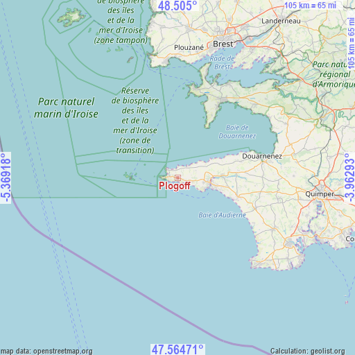
Plogoff GPS coordinates[2]
48° 2' 13.2" North, 4° 39' 57.816" West
| Map corner | latitude | longitude |
|---|---|---|
| Upper-left | 48.505°, | -5.36918° |
| Center: | 48.037°, | -4.66606° |
| Lower-right: | 47.56471°, | -3.96293° |
| Map W x H: | 104.6×104.5 km | = 65×64.9mi |
| max Lat: | 51.07786° ⇑40% North |
| Plogoff: | 48.037° |
| min Lat: | ⇓60% South 41.3874° |
| min Long | Plogoff | max Long |
| -5.08615° | -4.66606° | 9.52242° |
| W 0.1%⇐ | ⇒99.9% E |
Elevation
Elevation of Plogoff is 60 m = 197 ft, and this is 133.7 m = 439 ft below average elevation for this country.
| Max E: |
2333 m = 7654 ft | 77.8% |
| Avg. | 193.7 m = 635 ft | |
| Plogoff | 60 m = 197 ft | |
Min E: |
-1 m = -3 ft | 22.2% |
See also: France elevation on elevation.city.
Geographical zone
Plogoff is located in North temperate zone (between Tropic of Cancer and the Arctic Circle). Distance of this North polar circle is 2060 km =1280 mi to North.| Distance of | km | miles | from Plogoff |
|---|---|---|---|
| North Pole | 4665.8 | 2899.2 | to North |
| Arctic Circle | 2060 | 1280 | to North |
| Tropic Cancer | 2735.3 | 1699.6 | to South |
| Equator | 5341.2 | 3318.9 | to South |


Nearby cities:
15 places around Plogoff: (largest is in red/bold)
• Audierne
9.8 km =6.1 mi,  103°
103°
• Beuzec-Cap-Sizun
12.2 km =7.6 mi,  69°
69°
• Cléden-Cap-Sizun
1.9 km =1.2 mi,  48°
48°
• Confort-Meilars
17.4 km =10.8 mi,  85°
85°
• Douarnenez
25.9 km =16.1 mi,  75°
75°
• Esquibien
7.9 km =4.9 mi, 99°
• Landudec
24.9 km =15.5 mi, 99°
• Mahalon
17.2 km =10.7 mi, 90°
• Plouhinec
13.8 km =8.6 mi, 99°
• Plozévet
19.5 km =12.1 mi,  107°
107°
• Pont-Croix
13.3 km =8.3 mi, 88°
• Pouldergat
24.8 km =15.4 mi, 86°
• Pouldreuzic
24.3 km =15.1 mi, 113°
• Poullan-sur-Mer
19.2 km =11.9 mi, 74°
• Primelin
4.4 km =2.7 mi, 103°
Sources, notices
• [Note1] Compared only with cities in France existing in our database
• [Src1] Map data: © OpenStreetMap contributors (CC-BY-SA)
• [Src2] Other city data from geonames.org with taken over terms of usage.
• [Src3] Geographical zone / Annual Mean Temperature by Robert A. Rohde @ Wikipedia
