Allinges geodata
Allinges (Auvergne-Rhône-Alpes) is a populated place; located in France in Europe/Paris (GMT+2) time zone. With population of 3,355 people, there are 2912 cities with bigger population in this country. Compared to other cities in France, 61.8% of cities are located further ↑North; 91.5% of cities are located further ←West and 93.8% of cities have lower elevation than Allinges. Note1
Administrative division(s):
- Level 1: Auvergne-Rhône-Alpes
- Level 2: Haute-Savoie
- Level 3: Arrondissement de Thonon-les-Bains
- Level 4: Allinges


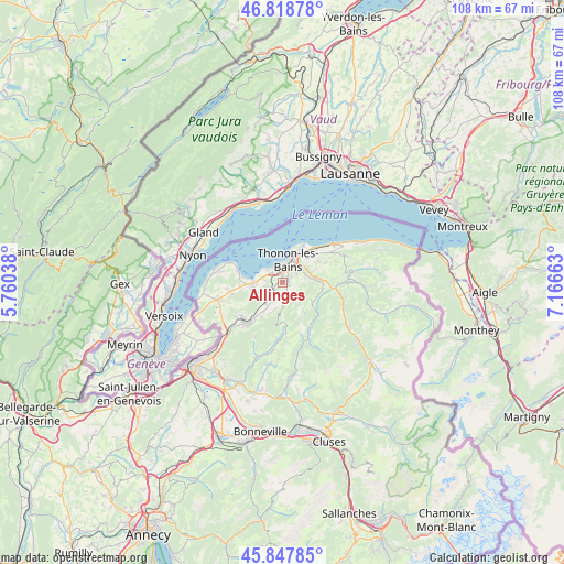
Allinges GPS coordinates[2]
46° 20' 7.692" North, 6° 27' 48.6" East
| Map corner | latitude | longitude |
|---|---|---|
| Upper-left | 46.81878°, | 5.76038° |
| Center: | 46.33547°, | 6.4635° |
| Lower-right: | 45.84785°, | 7.16663° |
| Map W x H: | 108×108 km | = 67.1×67.1mi |
| max Lat: | 51.07786° ⇑61.8% North |
| Allinges: | 46.33547° |
| min Lat: | ⇓38.2% South 41.3874° |
| min Long | Allinges | max Long |
| -5.08615° | 6.4635° | 9.52242° |
| W 91.5%⇐ | ⇒8.5% E |
Elevation
Elevation of Allinges is 532 m = 1745 ft, and this is 338.3 m = 1110 ft above average elevation for this country.
| Max E: |
2333 m = 7654 ft | 6.2% |
| Allinges | 532 m 1745 ft | |
| Avg. | 193.7 m = 635 ft | |
Min E: |
-1 m = -3 ft | 93.8% |
See also: France elevation on elevation.city.
Geographical zone
Allinges is located in North temperate zone (between Tropic of Cancer and the Arctic Circle). Distance of this North polar circle is 2249.2 km =1397.6 mi to North.| Distance of | km | miles | from Allinges |
|---|---|---|---|
| North Pole | 4855 | 3016.8 | to North |
| Arctic Circle | 2249.2 | 1397.6 | to North |
| Tropic Cancer | 2546.1 | 1582.1 | to South |
| Equator | 5152 | 3201.3 | to South |


Nearby cities:
15 places around Allinges: (largest is in red/bold)
• Anthy-sur-Léman
3.5 km =2.2 mi,  308°
308°
• Armoy
4.4 km =2.7 mi,  67°
67°
• Cervens
5.8 km =3.6 mi,  198°
198°
• Draillant
3.5 km =2.2 mi,  186°
186°
• Féternes
6.9 km =4.3 mi, 70°
• Lullin
7.3 km =4.5 mi,  140°
140°
• Lully
6.7 km =4.2 mi,  212°
212°
• Lyaud
4.8 km =3 mi,  84°
84°
• Margencel
3.8 km =2.4 mi,  279°
279°
• Marin
6.8 km =4.2 mi,  44°
44°
• Orcier
3.2 km =2 mi, 141°
• Perrignier
3.8 km =2.4 mi, 209°
• Sciez
6.1 km =3.8 mi,  266°
266°
• Thonon-les-Bains
4.1 km =2.5 mi,  17°
17°
• Vailly
6.9 km =4.3 mi,  122°
122°
Sources, notices
• [Note1] Compared only with cities in France existing in our database
• [Src1] Map data: © OpenStreetMap contributors (CC-BY-SA)
• [Src2] Other city data from geonames.org with taken over terms of usage.
• [Src3] Geographical zone / Annual Mean Temperature by Robert A. Rohde @ Wikipedia
