Aigues-Vives geodata
Aigues-Vives (Occitanie) is a populated place; located in France in Europe/Paris (GMT+2) time zone. With population of 510 people, there are 15036 cities with bigger population in this country. Compared to other cities in France, 98.3% of cities are located further ↑North; 58.6% of cities are located further →East and 90.2% of cities have lower elevation than Aigues-Vives. Note1
Administrative division(s):
- Level 1: Occitanie
- Level 2: Département de l'Ariège
- Level 3: Arrondissement de Pamiers
- Level 4: Aigues-Vives


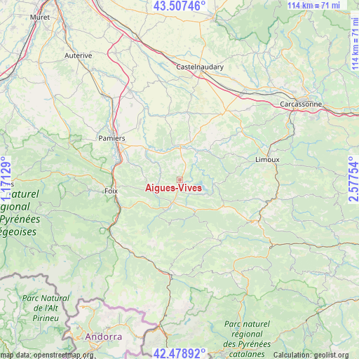
Aigues-Vives GPS coordinates[2]
42° 59' 43.224" North, 1° 52' 27.876" East
| Map corner | latitude | longitude |
|---|---|---|
| Upper-left | 43.50746°, | 1.17129° |
| Center: | 42.99534°, | 1.87441° |
| Lower-right: | 42.47892°, | 2.57754° |
| Map W x H: | 114.4×114.4 km | = 71.1×71.1mi |
| max Lat: | 51.07786° ⇑98.3% North |
| Aigues-Vives: | 42.99534° |
| min Lat: | ⇓1.7% South 41.3874° |
| min Long | Aigues-Vives | max Long |
| -5.08615° | 1.87441° | 9.52242° |
| W 41.4%⇐ | ⇒58.6% E |
Elevation
Elevation of Aigues-Vives is 430 m = 1411 ft, and this is 236.3 m = 775 ft above average elevation for this country.
| Max E: |
2333 m = 7654 ft | 9.8% |
| Aigues-Vives | 430 m 1411 ft | |
| Avg. | 193.7 m = 635 ft | |
Min E: |
-1 m = -3 ft | 90.2% |
See also: France elevation on elevation.city.
Geographical zone
Aigues-Vives is located in North temperate zone (between Tropic of Cancer and the Arctic Circle). Distance of this Northern Tropic circle is 2174.7 km =1351.3 mi to South.| Distance of | km | miles | from Aigues-Vives |
|---|---|---|---|
| North Pole | 5226.4 | 3247.5 | to North |
| Arctic Circle | 2620.5 | 1628.3 | to North |
| Tropic Cancer | 2174.7 | 1351.3 | to South |
| Equator | 4780.6 | 2970.5 | to South |


Nearby cities:
15 places around Aigues-Vives: (largest is in red/bold)
• Bélesta
11.4 km =7.1 mi,  155°
155°
• Chalabre
10.7 km =6.6 mi,  97°
97°
• Dalou
19.4 km =12.1 mi,  282°
282°
• Dun
7.1 km =4.4 mi,  300°
300°
• Fougax-et-Barrineuf
12.8 km =8 mi,  172°
172°
• La Bastide-sur-l’Hers
5.3 km =3.3 mi,  148°
148°
• Laroque-d’Olmes
3.1 km =1.9 mi,  191°
191°
• Lavelanet
7.5 km =4.7 mi,  197°
197°
• Les Pujols
16.4 km =10.2 mi,  308°
308°
• Léran
3 km =1.9 mi,  107°
107°
• Mirepoix
10.3 km =6.4 mi,  359°
359°
• Montferrier
13.5 km =8.4 mi,  212°
212°
• Saint-Paul-de-Jarrat
20.1 km =12.5 mi,  243°
243°
• Verniolle
20.7 km =12.9 mi, 297°
• Villeneuve-d’Olmes
10.9 km =6.8 mi, 204°
Sources, notices
• [Note1] Compared only with cities in France existing in our database
• [Src1] Map data: © OpenStreetMap contributors (CC-BY-SA)
• [Src2] Other city data from geonames.org with taken over terms of usage.
• [Src3] Geographical zone / Annual Mean Temperature by Robert A. Rohde @ Wikipedia
