Thiers geodata
Thiers (Provence-Alpes-Côte d'Azur) is a section of populated place; located in France in Europe/Paris (GMT+2) time zone. With population of 5,314 people, there are 1855 cities with bigger population in this country. Compared to other cities in France, 95.7% of cities are located further ↑North; 81.6% of cities are located further ←West and 85.9% of cities have higher elevation than Thiers. Note1
Administrative division(s):
- Level 1: Provence-Alpes-Côte d'Azur
- Level 2: Département des Bouches-du-Rhône
- Level 3: Arrondissement de Marseille
- Level 4: Marseille


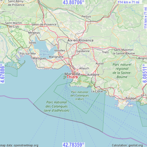
Thiers GPS coordinates[2]
43° 17' 50.928" North, 5° 22' 55.128" East
| Map corner | latitude | longitude |
|---|---|---|
| Upper-left | 43.80706°, | 4.67886° |
| Center: | 43.29748°, | 5.38198° |
| Lower-right: | 42.78359°, | 6.08511° |
| Map W x H: | 113.8×113.8 km | = 70.7×70.7mi |
| max Lat: | 51.07786° ⇑95.7% North |
| Thiers: | 43.29748° |
| min Lat: | ⇓4.3% South 41.3874° |
| min Long | Thiers | max Long |
| -5.08615° | 5.38198° | 9.52242° |
| W 81.6%⇐ | ⇒18.4% E |
Elevation
Elevation of Thiers is 40 m = 131 ft, and this is 153.7 m = 504 ft below average elevation for this country.
| Max E: |
2333 m = 7654 ft | 85.9% |
| Avg. | 193.7 m = 635 ft | |
| Thiers | 40 m = 131 ft | |
Min E: |
-1 m = -3 ft | 14.1% |
See also: France elevation on elevation.city.
Geographical zone
Thiers is located in North temperate zone (between Tropic of Cancer and the Arctic Circle). Distance of this Northern Tropic circle is 2208.3 km =1372.2 mi to South.| Distance of | km | miles | from Thiers |
|---|---|---|---|
| North Pole | 5192.8 | 3226.7 | to North |
| Arctic Circle | 2586.9 | 1607.4 | to North |
| Tropic Cancer | 2208.3 | 1372.2 | to South |
| Equator | 4814.2 | 2991.4 | to South |


Nearby cities:
15 places around Thiers: (largest is in red/bold)
• Belsunce
0.4 km =0.2 mi,  282°
282°
• Le Camas
1 km =0.6 mi,  107°
107°
• Le Chapitre
0.4 km =0.2 mi,  29°
29°
• Les Grands Carmes
0.8 km =0.5 mi,  293°
293°
• Marseille
0.1 km =0.1 mi,  231°
231°
• Marseille 01
0.2 km =0.1 mi,  66°
66°
• Marseille 02
0.9 km =0.6 mi,  264°
264°
• Marseille 03
0.8 km =0.5 mi,  318°
318°
• Marseille 06
1.1 km =0.7 mi,  191°
191°
• Marseille Prefecture
0.8 km =0.5 mi,  198°
198°
• Noailles
0.3 km =0.2 mi, 230°
• Notre-Dame du Mont
0.5 km =0.3 mi,  179°
179°
• Opéra
0.6 km =0.4 mi, 230°
• Saint-Charles
0.5 km =0.3 mi,  18°
18°
• Saint-Lazare
1.1 km =0.7 mi,  325°
325°
Sources, notices
• [Note1] Compared only with cities in France existing in our database
• [Src1] Map data: © OpenStreetMap contributors (CC-BY-SA)
• [Src2] Other city data from geonames.org with taken over terms of usage.
• [Src3] Geographical zone / Annual Mean Temperature by Robert A. Rohde @ Wikipedia
