Notre-Dame du Mont geodata
Notre-Dame du Mont (Provence-Alpes-Côte d'Azur) is a section of populated place; located in France in Europe/Paris (GMT+2) time zone. With population of 7,033 people, there are 1389 cities with bigger population in this country. Compared to other cities in France, 95.8% of cities are located further ↑North; 81.6% of cities are located further ←West and 85.9% of cities have higher elevation than Notre-Dame du Mont. Note1
Administrative division(s):
- Level 1: Provence-Alpes-Côte d'Azur
- Level 2: Département des Bouches-du-Rhône
- Level 3: Arrondissement de Marseille
- Level 4: Marseille


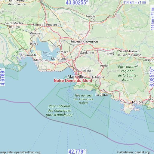
Notre-Dame du Mont GPS coordinates[2]
43° 17' 34.548" North, 5° 22' 55.308" East
| Map corner | latitude | longitude |
|---|---|---|
| Upper-left | 43.80255°, | 4.6789° |
| Center: | 43.29293°, | 5.38203° |
| Lower-right: | 42.779°, | 6.08515° |
| Map W x H: | 113.8×113.8 km | = 70.7×70.7mi |
| max Lat: | 51.07786° ⇑95.8% North |
| Notre-Dame du Mont: | 43.29293° |
| min Lat: | ⇓4.2% South 41.3874° |
| min Long | Notre-Dame du M | max Long |
| -5.08615° | 5.38203° | 9.52242° |
| W 81.6%⇐ | ⇒18.4% E |
Elevation
Elevation of Notre-Dame du Mont is 40 m = 131 ft, and this is 153.7 m = 504 ft below average elevation for this country.
| Max E: |
2333 m = 7654 ft | 85.9% |
| Avg. | 193.7 m = 635 ft | |
| Notre-Dame du Mont | 40 m = 131 ft | |
Min E: |
-1 m = -3 ft | 14.1% |
See also: France elevation on elevation.city.
Geographical zone
Notre-Dame du Mont is located in North temperate zone (between Tropic of Cancer and the Arctic Circle). Distance of this Northern Tropic circle is 2207.8 km =1371.9 mi to South.| Distance of | km | miles | from Notre-Dame du Mont |
|---|---|---|---|
| North Pole | 5193.3 | 3227 | to North |
| Arctic Circle | 2587.5 | 1607.8 | to North |
| Tropic Cancer | 2207.8 | 1371.9 | to South |
| Equator | 4813.7 | 2991.1 | to South |


Nearby cities:
15 places around Notre-Dame du Mont: (largest is in red/bold)
• Belsunce
0.7 km =0.4 mi,  323°
323°
• Castellane
0.8 km =0.5 mi,  175°
175°
• La Conception
1 km =0.6 mi,  97°
97°
• Le Camas
1 km =0.6 mi,  78°
78°
• Le Chapitre
0.9 km =0.6 mi,  12°
12°
• Lodi
0.9 km =0.6 mi,  141°
141°
• Marseille
0.5 km =0.3 mi,  350°
350°
• Marseille 01
0.6 km =0.4 mi,  15°
15°
• Marseille 06
0.6 km =0.4 mi,  201°
201°
• Marseille Prefecture
0.3 km =0.2 mi,  227°
227°
• Noailles
0.4 km =0.2 mi,  330°
330°
• Opéra
0.5 km =0.3 mi,  284°
284°
• Palais de Justice
0.9 km =0.6 mi,  214°
214°
• Saint-Charles
1 km =0.6 mi, 9°
• Thiers
0.5 km =0.3 mi,  359°
359°
Sources, notices
• [Note1] Compared only with cities in France existing in our database
• [Src1] Map data: © OpenStreetMap contributors (CC-BY-SA)
• [Src2] Other city data from geonames.org with taken over terms of usage.
• [Src3] Geographical zone / Annual Mean Temperature by Robert A. Rohde @ Wikipedia
