Wolverhampton geodata
Wolverhampton (England) is a seat of a second-order administrative division; located in United Kingdom in Europe/London (GMT+1) time zone. With population of 252,791 people, there are 29 cities with bigger population in this country. Compared to other cities in United Kingdom, 52.1% of cities are located further ↓South; 57.3% of cities are located further →East and 91.8% of cities have lower elevation than Wolverhampton. Note1


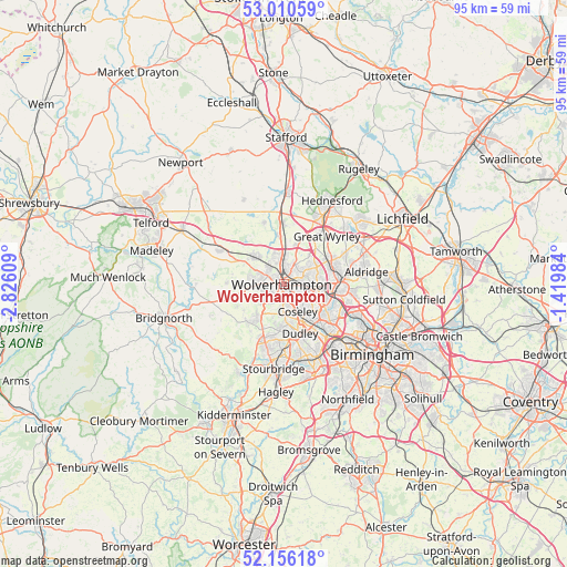
Wolverhampton GPS coordinates[2]
52° 35' 7.692" North, 2° 7' 22.656" West
| Map corner | latitude | longitude |
|---|---|---|
| Upper-left | 53.01059°, | -2.82609° |
| Center: | 52.58547°, | -2.12296° |
| Lower-right: | 52.15618°, | -1.41984° |
| Map W x H: | 95×95 km | = 59×59mi |
| max Lat: | 60.39635° ⇑47.9% North |
| Wolverhampton: | 52.58547° |
| min Lat: | ⇓52.1% South 34.60088° |
| min Long | Wolverhampton | max Long |
| -7.64133° | -2.12296° | 32.95536° |
| W 42.7%⇐ | ⇒57.3% E |
Elevation
Elevation of Wolverhampton is 160 m = 525 ft, and this is 87.1 m = 286 ft above average elevation for this country.
| Max E: |
515 m = 1690 ft | 8.2% |
| Wolverhampton | 160 m 525 ft | |
| Avg. | 72.9 m = 239 ft | |
Min E: |
-30 m = -98 ft | 91.8% |
See also: Wolverhampton elevation on elevation.city.
Geographical zone
Wolverhampton is located in North temperate zone (between Tropic of Cancer and the Arctic Circle). Distance of this North polar circle is 1554.2 km =965.7 mi to North.| Distance of | km | miles | from Wolverhampton |
|---|---|---|---|
| North Pole | 4160.1 | 2585 | to North |
| Arctic Circle | 1554.2 | 965.7 | to North |
| Tropic Cancer | 3241 | 2013.9 | to South |
| Equator | 5847 | 3633.2 | to South |


Nearby cities:
15 places around Wolverhampton: (largest is in red/bold)
• Bilston
4 km =2.5 mi,  123°
123°
• Bloxwich
8.8 km =5.5 mi,  65°
65°
• Codsall
7.2 km =4.5 mi,  312°
312°
• Coven
7.9 km =4.9 mi,  353°
353°
• Darlaston
6.4 km =4 mi,  109°
109°
• Essington
6.6 km =4.1 mi,  42°
42°
• Featherstone
6.9 km =4.3 mi,  16°
16°
• Seisdon
8.6 km =5.3 mi,  243°
243°
• Shareshill
8.3 km =5.2 mi, 19°
• Tipton
7.3 km =4.5 mi,  149°
149°
• Walsall
9.4 km =5.8 mi,  90°
90°
• Wednesbury
7.7 km =4.8 mi, 119°
• Wednesfield
2.8 km =1.7 mi,  64°
64°
• Willenhall
4.3 km =2.7 mi, 90°
• Wombourn
7.1 km =4.4 mi,  215°
215°
Sources, notices
• [Note1] Compared only with cities in United Kingdom existing in our database
• [Src1] Map data: © OpenStreetMap contributors (CC-BY-SA)
• [Src2] Other city data from geonames.org with taken over terms of usage.
• [Src3] Geographical zone / Annual Mean Temperature by Robert A. Rohde @ Wikipedia
