Wokingham geodata
Wokingham (England) is a seat of a second-order administrative division; located in United Kingdom in Europe/London (GMT+0) time zone. With population of 41,143 people, there are 297 cities with bigger population in this country. Compared to other cities in United Kingdom, 80.5% of cities are located further ↑North; 69.6% of cities are located further ←West and 57.1% of cities have lower elevation than Wokingham. Note1


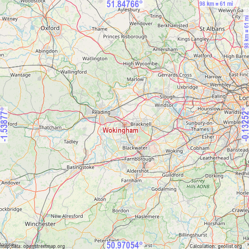
Wokingham GPS coordinates[2]
51° 24' 40.32" North, 0° 50' 8.34" West
| Map corner | latitude | longitude |
|---|---|---|
| Upper-left | 51.84766°, | -1.53877° |
| Center: | 51.4112°, | -0.83565° |
| Lower-right: | 50.97054°, | -0.13252° |
| Map W x H: | 97.5×97.5 km | = 60.6×60.6mi |
| max Lat: | 60.39635° ⇑80.5% North |
| Wokingham: | 51.4112° |
| min Lat: | ⇓19.5% South 34.60088° |
| min Long | Wokingham | max Long |
| -7.64133° | -0.83565° | 32.95536° |
| W 69.6%⇐ | ⇒30.4% E |
Elevation
Elevation of Wokingham is 72 m = 236 ft, and this is 0.90000000000001 m = 3 ft below average elevation for this country.
| Max E: |
515 m = 1690 ft | 42.9% |
| Avg. | 72.9 m = 239 ft | |
| Wokingham | 72 m = 236 ft | |
Min E: |
-30 m = -98 ft | 57.1% |
See also: Wokingham elevation on elevation.city.
Geographical zone
Wokingham is located in North temperate zone (between Tropic of Cancer and the Arctic Circle). Distance of this North polar circle is 1684.8 km =1046.9 mi to North.| Distance of | km | miles | from Wokingham |
|---|---|---|---|
| North Pole | 4290.7 | 2666.1 | to North |
| Arctic Circle | 1684.8 | 1046.9 | to North |
| Tropic Cancer | 3110.5 | 1932.8 | to South |
| Equator | 5716.4 | 3552 | to South |


Nearby cities:
15 places around Wokingham: (largest is in red/bold)
• Barkham
3.2 km =2 mi,  242°
242°
• Binfield
4 km =2.5 mi,  55°
55°
• Bracknell
5.9 km =3.7 mi,  87°
87°
• Crowthorne
5.5 km =3.4 mi,  146°
146°
• Earley
6.9 km =4.3 mi,  298°
298°
• Eversley
7.4 km =4.6 mi,  210°
210°
• Finchampstead
5.7 km =3.5 mi,  195°
195°
• Hurst
5.3 km =3.3 mi,  347°
347°
• Lower Earley
6.1 km =3.8 mi,  286°
286°
• Sandhurst
7.9 km =4.9 mi, 154°
• Shinfield
7.6 km =4.7 mi,  265°
265°
• Twyford
7.3 km =4.5 mi, 346°
• Winnersh
3.6 km =2.2 mi, 300°
• Woodley
5.4 km =3.4 mi,  322°
322°
• Yateley
7.6 km =4.7 mi,  176°
176°
Sources, notices
• [Note1] Compared only with cities in United Kingdom existing in our database
• [Src1] Map data: © OpenStreetMap contributors (CC-BY-SA)
• [Src2] Other city data from geonames.org with taken over terms of usage.
• [Src3] Geographical zone / Annual Mean Temperature by Robert A. Rohde @ Wikipedia
