Bracknell geodata
Bracknell (England) is a seat of a second-order administrative division; located in United Kingdom in Europe/London (GMT+1) time zone. With population of 76,103 people, there are 134 cities with bigger population in this country. Compared to other cities in United Kingdom, 80.5% of cities are located further ↑North; 71.3% of cities are located further ←West and 62.7% of cities have lower elevation than Bracknell. Note1


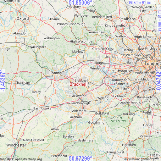
Bracknell GPS coordinates[2]
51° 24' 49.068" North, 0° 45' 1.944" West
| Map corner | latitude | longitude |
|---|---|---|
| Upper-left | 51.85006°, | -1.45367° |
| Center: | 51.41363°, | -0.75054° |
| Lower-right: | 50.97299°, | -0.04742° |
| Map W x H: | 97.5×97.5 km | = 60.6×60.6mi |
| max Lat: | 60.39635° ⇑80.5% North |
| Bracknell: | 51.41363° |
| min Lat: | ⇓19.5% South 34.60088° |
| min Long | Bracknell | max Long |
| -7.64133° | -0.75054° | 32.95536° |
| W 71.3%⇐ | ⇒28.7% E |
Elevation
Elevation of Bracknell is 81 m = 266 ft, and this is 8.1 m = 27 ft above average elevation for this country.
| Max E: |
515 m = 1690 ft | 37.3% |
| Bracknell | 81 m 266 ft | |
| Avg. | 72.9 m = 239 ft | |
Min E: |
-30 m = -98 ft | 62.7% |
See also: Bracknell elevation on elevation.city.
Geographical zone
Bracknell is located in North temperate zone (between Tropic of Cancer and the Arctic Circle). Distance of this North polar circle is 1684.5 km =1046.7 mi to North.| Distance of | km | miles | from Bracknell |
|---|---|---|---|
| North Pole | 4290.4 | 2665.9 | to North |
| Arctic Circle | 1684.5 | 1046.7 | to North |
| Tropic Cancer | 3110.7 | 1932.9 | to South |
| Equator | 5716.7 | 3552.2 | to South |


Nearby cities:
15 places around Bracknell: (largest is in red/bold)
• Ascot
5.3 km =3.3 mi,  93°
93°
• Bagshot
7.3 km =4.5 mi,  143°
143°
• Barkham
8.9 km =5.5 mi,  258°
258°
• Binfield
3.3 km =2.1 mi,  307°
307°
• Camberley
8.5 km =5.3 mi,  176°
176°
• Crowthorne
5.6 km =3.5 mi,  210°
210°
• Hurst
8.6 km =5.3 mi, 305°
• Lightwater
9.1 km =5.7 mi, 142°
• Sandhurst
7.8 km =4.8 mi,  198°
198°
• Sunningdale
8.6 km =5.3 mi,  101°
101°
• Waltham St Lawrence
8.9 km =5.5 mi,  333°
333°
• Warfield
3.5 km =2.2 mi,  26°
26°
• White Waltham
8.9 km =5.5 mi,  350°
350°
• Windlesham
8.6 km =5.3 mi,  129°
129°
• Wokingham
5.9 km =3.7 mi,  267°
267°
Sources, notices
• [Note1] Compared only with cities in United Kingdom existing in our database
• [Src1] Map data: © OpenStreetMap contributors (CC-BY-SA)
• [Src2] Other city data from geonames.org with taken over terms of usage.
• [Src3] Geographical zone / Annual Mean Temperature by Robert A. Rohde @ Wikipedia
