Whitehaven geodata
Whitehaven (England) is a populated place; located in United Kingdom in Europe/London (GMT+1) time zone. With population of 24,900 people, there are 479 cities with bigger population in this country. Compared to other cities in United Kingdom, 82.5% of cities are located further ↓South; 83.4% of cities are located further →East and 82% of cities have higher elevation than Whitehaven. Note1


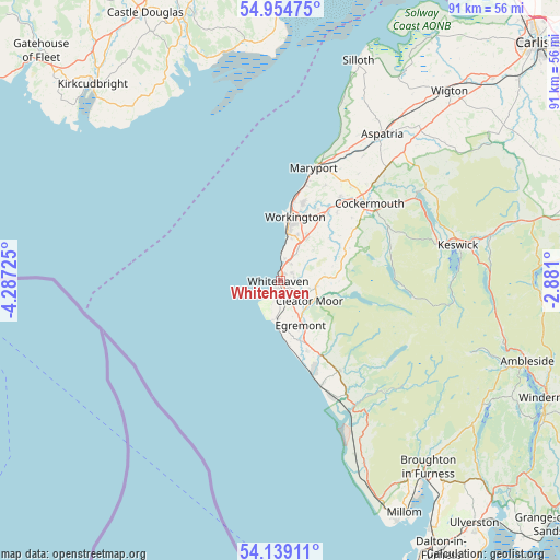
Whitehaven GPS coordinates[2]
54° 32' 56.292" North, 3° 35' 2.832" West
| Map corner | latitude | longitude |
|---|---|---|
| Upper-left | 54.95475°, | -4.28725° |
| Center: | 54.54897°, | -3.58412° |
| Lower-right: | 54.13911°, | -2.881° |
| Map W x H: | 90.7×90.7 km | = 56.4×56.4mi |
| max Lat: | 60.39635° ⇑17.5% North |
| Whitehaven: | 54.54897° |
| min Lat: | ⇓82.5% South 34.60088° |
| min Long | Whitehaven | max Long |
| -7.64133° | -3.58412° | 32.95536° |
| W 16.6%⇐ | ⇒83.4% E |
Elevation
Elevation of Whitehaven is 19 m = 62 ft, and this is 53.9 m = 177 ft below average elevation for this country.
| Max E: |
515 m = 1690 ft | 82% |
| Avg. | 72.9 m = 239 ft | |
| Whitehaven | 19 m = 62 ft | |
Min E: |
-30 m = -98 ft | 18% |
See also: United Kingdom elevation on elevation.city.
Geographical zone
Whitehaven is located in North temperate zone (between Tropic of Cancer and the Arctic Circle). Distance of this North polar circle is 1335.9 km =830.1 mi to North.| Distance of | km | miles | from Whitehaven |
|---|---|---|---|
| North Pole | 3941.8 | 2449.3 | to North |
| Arctic Circle | 1335.9 | 830.1 | to North |
| Tropic Cancer | 3459.4 | 2149.6 | to South |
| Equator | 6065.3 | 3768.8 | to South |


Nearby cities:
15 places around Whitehaven: (largest is in red/bold)
• Arlecdon
7.4 km =4.6 mi,  85°
85°
• Beckermet
11.8 km =7.3 mi,  158°
158°
• Brigham
16.3 km =10.1 mi,  41°
41°
• Broughton Moor
17.1 km =10.6 mi,  25°
25°
• Cleator Moor
5.4 km =3.4 mi,  124°
124°
• Distington
6.1 km =3.8 mi, 28°
• Egremont
8.6 km =5.3 mi,  154°
154°
• Flimby
16.2 km =10.1 mi,  14°
14°
• Frizington
5.8 km =3.6 mi,  97°
97°
• Gosforth
17.6 km =10.9 mi, 146°
• Lowca
3.6 km =2.2 mi, 14°
• Moor Row
4.8 km =3 mi,  141°
141°
• Saint Bees
6.4 km =4 mi,  183°
183°
• Seascale
18.1 km =11.2 mi, 158°
• Workington
10.7 km =6.6 mi, 13°
Sources, notices
• [Note1] Compared only with cities in United Kingdom existing in our database
• [Src1] Map data: © OpenStreetMap contributors (CC-BY-SA)
• [Src2] Other city data from geonames.org with taken over terms of usage.
• [Src3] Geographical zone / Annual Mean Temperature by Robert A. Rohde @ Wikipedia
