Seascale geodata
Seascale (England) is a populated place; located in United Kingdom in Europe/London (GMT+1) time zone. With population of 1,754 people, there are 2815 cities with bigger population in this country. Compared to other cities in United Kingdom, 81.2% of cities are located further ↓South; 82% of cities are located further →East and 80.8% of cities have higher elevation than Seascale. Note1
Administrative division(s):
- Level 1: England
- Level 2: Cumbria
- Level 3: Copeland District
- Level 4: Seascale


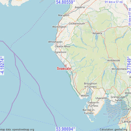
Seascale GPS coordinates[2]
54° 23' 53.916" North, 3° 28' 46.596" West
| Map corner | latitude | longitude |
|---|---|---|
| Upper-left | 54.80559°, | -4.18274° |
| Center: | 54.39831°, | -3.47961° |
| Lower-right: | 53.98694°, | -2.77649° |
| Map W x H: | 91×91 km | = 56.5×56.5mi |
| max Lat: | 60.39635° ⇑18.8% North |
| Seascale: | 54.39831° |
| min Lat: | ⇓81.2% South 34.60088° |
| min Long | Seascale | max Long |
| -7.64133° | -3.47961° | 32.95536° |
| W 18%⇐ | ⇒82% E |
Elevation
Elevation of Seascale is 20 m = 66 ft, and this is 52.9 m = 174 ft below average elevation for this country.
| Max E: |
515 m = 1690 ft | 80.8% |
| Avg. | 72.9 m = 239 ft | |
| Seascale | 20 m = 66 ft | |
Min E: |
-30 m = -98 ft | 19.2% |
See also: United Kingdom elevation on elevation.city.
Geographical zone
Seascale is located in North temperate zone (between Tropic of Cancer and the Arctic Circle). Distance of this North polar circle is 1352.6 km =840.5 mi to North.| Distance of | km | miles | from Seascale |
|---|---|---|---|
| North Pole | 3958.5 | 2459.7 | to North |
| Arctic Circle | 1352.6 | 840.5 | to North |
| Tropic Cancer | 3442.6 | 2139.1 | to South |
| Equator | 6048.5 | 3758.4 | to South |


Nearby cities:
15 places around Seascale: (largest is in red/bold)
• Arlecdon
17.3 km =10.7 mi,  2°
2°
• Beckermet
6.2 km =3.9 mi,  337°
337°
• Broughton in Furness
22 km =13.7 mi,  127°
127°
• Cleator Moor
13.9 km =8.6 mi,  350°
350°
• Coniston
26.4 km =16.4 mi,  97°
97°
• Distington
22.5 km =14 mi, 350°
• Egremont
9.5 km =5.9 mi, 341°
• Frizington
16 km =9.9 mi,  356°
356°
• Gosforth
3.6 km =2.2 mi,  54°
54°
• Haverigg
25.2 km =15.7 mi,  151°
151°
• Lowca
21.1 km =13.1 mi, 343°
• Millom
24.8 km =15.4 mi, 147°
• Moor Row
13.5 km =8.4 mi, 343°
• Saint Bees
12.6 km =7.8 mi,  325°
325°
• Whitehaven
18.1 km =11.2 mi, 338°
Sources, notices
• [Note1] Compared only with cities in United Kingdom existing in our database
• [Src1] Map data: © OpenStreetMap contributors (CC-BY-SA)
• [Src2] Other city data from geonames.org with taken over terms of usage.
• [Src3] Geographical zone / Annual Mean Temperature by Robert A. Rohde @ Wikipedia
