Westbury-sub-Mendip geodata
Westbury-sub-Mendip (England) is a populated place; located in United Kingdom in Europe/London (GMT+1) time zone. With population of 801 people, there are 4025 cities with bigger population in this country. Compared to other cities in United Kingdom, 85.9% of cities are located further ↑North; 69.1% of cities are located further →East and 65.5% of cities have higher elevation than Westbury-sub-Mendip. Note1
Administrative division(s):
- Level 1: England
- Level 2: Somerset
- Level 3: Mendip District
- Level 4: Westbury


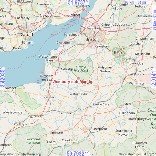
Westbury-sub-Mendip GPS coordinates[2]
51° 14' 8.016" North, 2° 43' 1.992" West
| Map corner | latitude | longitude |
|---|---|---|
| Upper-left | 51.6737°, | -3.42035° |
| Center: | 51.23556°, | -2.71722° |
| Lower-right: | 50.79321°, | -2.0141° |
| Map W x H: | 97.9×97.9 km | = 60.8×60.8mi |
| max Lat: | 60.39635° ⇑85.9% North |
| Westbury-sub-Mendip: | 51.23556° |
| min Lat: | ⇓14.1% South 34.60088° |
| min Long | Westbury-sub-Me | max Long |
| -7.64133° | -2.71722° | 32.95536° |
| W 30.9%⇐ | ⇒69.1% E |
Elevation
Elevation of Westbury-sub-Mendip is 39 m = 128 ft, and this is 33.9 m = 111 ft below average elevation for this country.
| Max E: |
515 m = 1690 ft | 65.5% |
| Avg. | 72.9 m = 239 ft | |
| Westbury-sub-Mendip | 39 m = 128 ft | |
Min E: |
-30 m = -98 ft | 34.5% |
See also: United Kingdom elevation on elevation.city.
Geographical zone
Westbury-sub-Mendip is located in North temperate zone (between Tropic of Cancer and the Arctic Circle). Distance of this North polar circle is 1704.3 km =1059 mi to North.| Distance of | km | miles | from Westbury-sub-Mendip |
|---|---|---|---|
| North Pole | 4310.2 | 2678.2 | to North |
| Arctic Circle | 1704.3 | 1059 | to North |
| Tropic Cancer | 3090.9 | 1920.6 | to South |
| Equator | 5696.9 | 3539.9 | to South |


Nearby cities:
15 places around Westbury-sub-Mendip: (largest is in red/bold)
• Axbridge
9 km =5.6 mi,  307°
307°
• Blackford
9.2 km =5.7 mi,  263°
263°
• Blagdon
10.2 km =6.3 mi,  359°
359°
• Bradley Cross
5.4 km =3.4 mi,  324°
324°
• Cheddar
6.1 km =3.8 mi, 316°
• Compton Martin
9.4 km =5.8 mi,  27°
27°
• Croscombe
9.9 km =6.2 mi,  115°
115°
• Draycott
3.3 km =2.1 mi, 314°
• East Harptree
9.9 km =6.2 mi,  42°
42°
• Glastonbury
9.8 km =6.1 mi,  181°
181°
• Henton
3.4 km =2.1 mi,  191°
191°
• Mendip
6.3 km =3.9 mi,  88°
88°
• Wedmore
6.6 km =4.1 mi, 262°
• Wells
5.7 km =3.5 mi, 122°
• Wookey
3.4 km =2.1 mi,  148°
148°
Sources, notices
• [Note1] Compared only with cities in United Kingdom existing in our database
• [Src1] Map data: © OpenStreetMap contributors (CC-BY-SA)
• [Src2] Other city data from geonames.org with taken over terms of usage.
• [Src3] Geographical zone / Annual Mean Temperature by Robert A. Rohde @ Wikipedia
