Mendip geodata
Mendip (England) is a section of populated place; located in United Kingdom in Europe/London (GMT+1) time zone. With population of 110,000 people, there are 85 cities with bigger population in this country. Compared to other cities in United Kingdom, 85.8% of cities are located further ↑North; 67.4% of cities are located further →East and 99.5% of cities have lower elevation than Mendip. Note1
Administrative division(s):
- Level 1: England
- Level 2: Somerset
- Level 3: Mendip District
- Level 4: St. Cuthbert Out


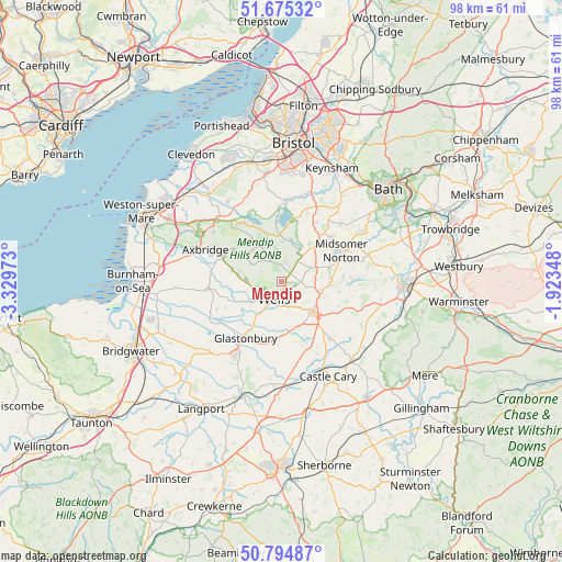
Mendip GPS coordinates[2]
51° 14' 13.92" North, 2° 37' 35.76" West
| Map corner | latitude | longitude |
|---|---|---|
| Upper-left | 51.67532°, | -3.32973° |
| Center: | 51.2372°, | -2.6266° |
| Lower-right: | 50.79487°, | -1.92348° |
| Map W x H: | 97.9×97.9 km | = 60.8×60.8mi |
| max Lat: | 60.39635° ⇑85.8% North |
| Mendip: | 51.2372° |
| min Lat: | ⇓14.2% South 34.60088° |
| min Long | Mendip | max Long |
| -7.64133° | -2.6266° | 32.95536° |
| W 32.6%⇐ | ⇒67.4% E |
Elevation
Elevation of Mendip is 293 m = 961 ft, and this is 220.1 m = 722 ft above average elevation for this country.
| Max E: |
515 m = 1690 ft | 0.5% |
| Mendip | 293 m 961 ft | |
| Avg. | 72.9 m = 239 ft | |
Min E: |
-30 m = -98 ft | 99.5% |
See also: Mendip elevation on elevation.city.
Geographical zone
Mendip is located in North temperate zone (between Tropic of Cancer and the Arctic Circle). Distance of this North polar circle is 1704.1 km =1058.9 mi to North.| Distance of | km | miles | from Mendip |
|---|---|---|---|
| North Pole | 4310 | 2678.1 | to North |
| Arctic Circle | 1704.1 | 1058.9 | to North |
| Tropic Cancer | 3091.1 | 1920.7 | to South |
| Equator | 5697 | 3540 | to South |


Nearby cities:
15 places around Mendip: (largest is in red/bold)
• Cameley
9.9 km =6.2 mi,  27°
27°
• Chilcompton
9 km =5.6 mi,  70°
70°
• Compton Martin
8.4 km =5.2 mi,  346°
346°
• Croscombe
5.2 km =3.2 mi,  149°
149°
• Draycott
8.9 km =5.5 mi,  283°
283°
• East Harptree
7.1 km =4.4 mi,  2°
2°
• Farrington Gurney
9.6 km =6 mi,  45°
45°
• Henton
7.8 km =4.8 mi,  243°
243°
• Oakhill
7.1 km =4.4 mi,  102°
102°
• Pilton
8.5 km =5.3 mi,  161°
161°
• Shepton Mallet
7.6 km =4.7 mi,  133°
133°
• Stratton-on-the-Fosse
9.5 km =5.9 mi,  79°
79°
• Wells
3.6 km =2.2 mi,  205°
205°
• Westbury-sub-Mendip
6.3 km =3.9 mi,  268°
268°
• Wookey
5.5 km =3.4 mi, 236°
Sources, notices
• [Note1] Compared only with cities in United Kingdom existing in our database
• [Src1] Map data: © OpenStreetMap contributors (CC-BY-SA)
• [Src2] Other city data from geonames.org with taken over terms of usage.
• [Src3] Geographical zone / Annual Mean Temperature by Robert A. Rohde @ Wikipedia
