Truro geodata
Truro (England) is a seat of a second-order administrative division; located in United Kingdom in Europe/London (GMT+1) time zone. With population of 23,041 people, there are 518 cities with bigger population in this country. Compared to other cities in United Kingdom, 99.2% of cities are located further ↑North; 96.4% of cities are located further →East and 85.8% of cities have higher elevation than Truro. Note1


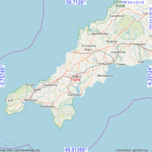
Truro GPS coordinates[2]
50° 15' 54.936" North, 5° 3' 15.696" West
| Map corner | latitude | longitude |
|---|---|---|
| Upper-left | 50.7126°, | -5.75749° |
| Center: | 50.26526°, | -5.05436° |
| Lower-right: | 49.81368°, | -4.35124° |
| Map W x H: | 100×99.9 km | = 62.1×62.1mi |
| max Lat: | 60.39635° ⇑99.2% North |
| Truro: | 50.26526° |
| min Lat: | ⇓0.8% South 34.60088° |
| min Long | Truro | max Long |
| -7.64133° | -5.05436° | 32.95536° |
| W 3.6%⇐ | ⇒96.4% E |
Elevation
Elevation of Truro is 15 m = 49 ft, and this is 57.9 m = 190 ft below average elevation for this country.
| Max E: |
515 m = 1690 ft | 85.8% |
| Avg. | 72.9 m = 239 ft | |
| Truro | 15 m = 49 ft | |
Min E: |
-30 m = -98 ft | 14.2% |
See also: United Kingdom elevation on elevation.city.
Geographical zone
Truro is located in North temperate zone (between Tropic of Cancer and the Arctic Circle). Distance of this North polar circle is 1812.2 km =1126 mi to North.| Distance of | km | miles | from Truro |
|---|---|---|---|
| North Pole | 4418.1 | 2745.3 | to North |
| Arctic Circle | 1812.2 | 1126 | to North |
| Tropic Cancer | 2983.1 | 1853.6 | to South |
| Equator | 5589 | 3472.8 | to South |


Nearby cities:
15 places around Truro: (largest is in red/bold)
• Chacewater
7.4 km =4.6 mi,  262°
262°
• Flushing
11.2 km =7 mi,  185°
185°
• Gerrans
10.9 km =6.8 mi,  151°
151°
• Grampound
11.6 km =7.2 mi,  70°
70°
• Mount Hawke
11.1 km =6.9 mi,  279°
279°
• Mylor Bridge
9.1 km =5.7 mi, 191°
• Penryn
11.4 km =7.1 mi,  198°
198°
• Perranarworthal
8.1 km =5 mi,  215°
215°
• Perranporth
11.3 km =7 mi,  320°
320°
• Perranwell
7.4 km =4.6 mi, 219°
• Ponsanooth
9.7 km =6 mi, 220°
• Portscatho
11.8 km =7.3 mi, 150°
• Probus
7.8 km =4.8 mi, 66°
• St. Day
9.8 km =6.1 mi,  252°
252°
• Tregoney
9.8 km =6.1 mi,  88°
88°
Sources, notices
• [Note1] Compared only with cities in United Kingdom existing in our database
• [Src1] Map data: © OpenStreetMap contributors (CC-BY-SA)
• [Src2] Other city data from geonames.org with taken over terms of usage.
• [Src3] Geographical zone / Annual Mean Temperature by Robert A. Rohde @ Wikipedia
