Gerrans geodata
Gerrans (England) is a populated place; located in United Kingdom in Europe/London (GMT+1) time zone. With population of 535 people, there are 4785 cities with bigger population in this country. Compared to other cities in United Kingdom, 99.5% of cities are located further ↑North; 96.2% of cities are located further →East and 55.9% of cities have higher elevation than Gerrans. Note1


Gerrans GPS coordinates[2]
50° 10' 43.068" North, 4° 58' 53.976" West
| Map corner | latitude | longitude |
|---|---|---|
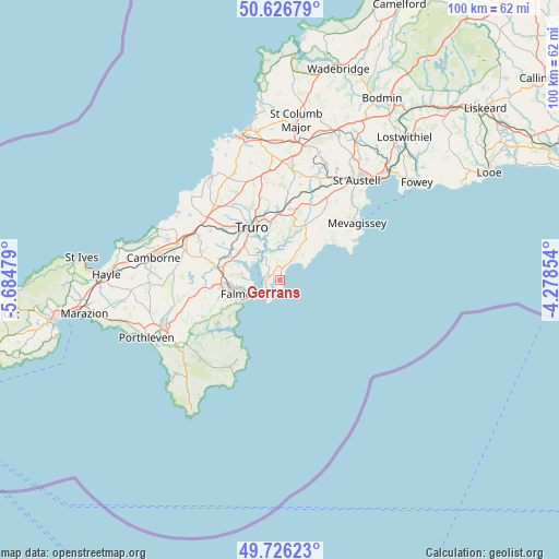
| Upper-left | 50.62679°, | -5.68479° |
| Center: | 50.17863°, | -4.98166° |
| Lower-right: | 49.72623°, | -4.27854° |
| Map W x H: | 100.1×100.1 km | = 62.2×62.2mi |
| max Lat: | 60.39635° ⇑99.5% North |
| Gerrans: | 50.17863° |
| min Lat: | ⇓0.5% South 34.60088° |
| min Long | Gerrans | max Long |
| -7.64133° | -4.98166° | 32.95536° |
| W 3.8%⇐ | ⇒96.2% E |
Elevation
Elevation of Gerrans is 52 m = 171 ft, and this is 20.9 m = 69 ft below average elevation for this country.
| Max E: |
515 m = 1690 ft | 55.9% |
| Avg. | 72.9 m = 239 ft | |
| Gerrans | 52 m = 171 ft | |
Min E: |
-30 m = -98 ft | 44.1% |
See also: United Kingdom elevation on elevation.city.
Geographical zone
Gerrans is located in North temperate zone (between Tropic of Cancer and the Arctic Circle). Distance of this North polar circle is 1821.8 km =1132 mi to North.| Distance of | km | miles | from Gerrans |
|---|---|---|---|
| North Pole | 4427.7 | 2751.2 | to North |
| Arctic Circle | 1821.8 | 1132 | to North |
| Tropic Cancer | 2973.4 | 1847.6 | to South |
| Equator | 5579.3 | 3466.8 | to South |


Nearby cities:
15 places around Gerrans: (largest is in red/bold)
• Chacewater
15.2 km =9.4 mi,  304°
304°
• Falmouth
6.9 km =4.3 mi,  247°
247°
• Flushing
6.5 km =4 mi,  256°
256°
• Gorran Haven
15.3 km =9.5 mi,  62°
62°
• Grampound
14.6 km =9.1 mi,  23°
23°
• Mylor Bridge
7 km =4.3 mi,  275°
275°
• Penryn
8.8 km =5.5 mi, 262°
• Perranarworthal
10.3 km =6.4 mi,  287°
287°
• Perranwell
10.6 km =6.6 mi, 291°
• Ponsanooth
11.7 km =7.3 mi, 281°
• Portscatho
0.9 km =0.6 mi,  138°
138°
• Probus
12.8 km =8 mi,  8°
8°
• Stithians
14 km =8.7 mi,  274°
274°
• Tregoney
10.9 km =6.8 mi,  25°
25°
• Truro
10.9 km =6.8 mi,  331°
331°
Sources, notices
• [Note1] Compared only with cities in United Kingdom existing in our database
• [Src1] Map data: © OpenStreetMap contributors (CC-BY-SA)
• [Src2] Other city data from geonames.org with taken over terms of usage.
• [Src3] Geographical zone / Annual Mean Temperature by Robert A. Rohde @ Wikipedia
