Trowbridge geodata
Trowbridge (England) is a seat of a second-order administrative division; located in United Kingdom in Europe/London (GMT+1) time zone. With population of 40,952 people, there are 299 cities with bigger population in this country. Compared to other cities in United Kingdom, 83.6% of cities are located further ↑North; 59.4% of cities are located further →East and 64% of cities have higher elevation than Trowbridge. Note1


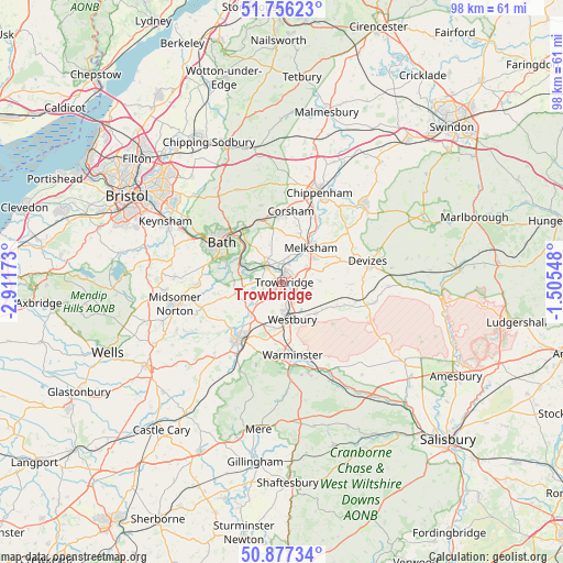
Trowbridge GPS coordinates[2]
51° 19' 8.004" North, 2° 12' 30.996" West
| Map corner | latitude | longitude |
|---|---|---|
| Upper-left | 51.75623°, | -2.91173° |
| Center: | 51.31889°, | -2.20861° |
| Lower-right: | 50.87734°, | -1.50548° |
| Map W x H: | 97.7×97.7 km | = 60.7×60.7mi |
| max Lat: | 60.39635° ⇑83.6% North |
| Trowbridge: | 51.31889° |
| min Lat: | ⇓16.4% South 34.60088° |
| min Long | Trowbridge | max Long |
| -7.64133° | -2.20861° | 32.95536° |
| W 40.6%⇐ | ⇒59.4% E |
Elevation
Elevation of Trowbridge is 41 m = 135 ft, and this is 31.9 m = 105 ft below average elevation for this country.
| Max E: |
515 m = 1690 ft | 64% |
| Avg. | 72.9 m = 239 ft | |
| Trowbridge | 41 m = 135 ft | |
Min E: |
-30 m = -98 ft | 36% |
See also: Trowbridge elevation on elevation.city.
Geographical zone
Trowbridge is located in North temperate zone (between Tropic of Cancer and the Arctic Circle). Distance of this North polar circle is 1695 km =1053.2 mi to North.| Distance of | km | miles | from Trowbridge |
|---|---|---|---|
| North Pole | 4300.9 | 2672.5 | to North |
| Arctic Circle | 1695 | 1053.2 | to North |
| Tropic Cancer | 3100.2 | 1926.4 | to South |
| Equator | 5706.1 | 3545.6 | to South |


Nearby cities:
15 places around Trowbridge: (largest is in red/bold)
• Bradford-on-Avon
4.3 km =2.7 mi,  317°
317°
• Bratton
7.9 km =4.9 mi,  132°
132°
• Broughton Gifford
6.4 km =4 mi,  21°
21°
• Freshford
6.9 km =4.3 mi,  288°
288°
• Holt
4.2 km =2.6 mi,  10°
10°
• Limpley Stoke
7.9 km =4.9 mi, 291°
• Melksham
7.7 km =4.8 mi,  38°
38°
• North Bradley
2.7 km =1.7 mi,  174°
174°
• Rode
6.4 km =4 mi,  232°
232°
• Semington
5.1 km =3.2 mi,  55°
55°
• Southwick
3 km =1.9 mi,  214°
214°
• Steeple Ashton
5.2 km =3.2 mi,  100°
100°
• Westbury
6.7 km =4.2 mi, 167°
• Westwood
5.2 km =3.2 mi, 289°
• Wingfield
3.6 km =2.2 mi,  260°
260°
Sources, notices
• [Note1] Compared only with cities in United Kingdom existing in our database
• [Src1] Map data: © OpenStreetMap contributors (CC-BY-SA)
• [Src2] Other city data from geonames.org with taken over terms of usage.
• [Src3] Geographical zone / Annual Mean Temperature by Robert A. Rohde @ Wikipedia
