Bradford-on-Avon geodata
Bradford-on-Avon (England) is a populated place; located in United Kingdom in Europe/London (GMT+1) time zone. With population of 9,274 people, there are 1116 cities with bigger population in this country. Compared to other cities in United Kingdom, 82.7% of cities are located further ↑North; 60.3% of cities are located further →East and 70% of cities have higher elevation than Bradford-on-Avon. Note1


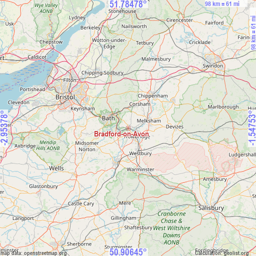
Bradford-on-Avon GPS coordinates[2]
51° 20' 51.792" North, 2° 15' 2.34" West
| Map corner | latitude | longitude |
|---|---|---|
| Upper-left | 51.78478°, | -2.95378° |
| Center: | 51.34772°, | -2.25065° |
| Lower-right: | 50.90645°, | -1.54753° |
| Map W x H: | 97.7×97.7 km | = 60.7×60.7mi |
| max Lat: | 60.39635° ⇑82.7% North |
| Bradford-on-Avon: | 51.34772° |
| min Lat: | ⇓17.3% South 34.60088° |
| min Long | Bradford-on-Avo | max Long |
| -7.64133° | -2.25065° | 32.95536° |
| W 39.7%⇐ | ⇒60.3% E |
Elevation
Elevation of Bradford-on-Avon is 33 m = 108 ft, and this is 39.9 m = 131 ft below average elevation for this country.
| Max E: |
515 m = 1690 ft | 70% |
| Avg. | 72.9 m = 239 ft | |
| Bradford-on-Avon | 33 m = 108 ft | |
Min E: |
-30 m = -98 ft | 30% |
See also: United Kingdom elevation on elevation.city.
Geographical zone
Bradford-on-Avon is located in North temperate zone (between Tropic of Cancer and the Arctic Circle). Distance of this North polar circle is 1691.8 km =1051.2 mi to North.| Distance of | km | miles | from Bradford-on-Avon |
|---|---|---|---|
| North Pole | 4297.7 | 2670.5 | to North |
| Arctic Circle | 1691.8 | 1051.2 | to North |
| Tropic Cancer | 3103.4 | 1928.4 | to South |
| Equator | 5709.3 | 3547.6 | to South |


Nearby cities:
15 places around Bradford-on-Avon: (largest is in red/bold)
• Atworth
6.4 km =4 mi,  38°
38°
• Bathford
6.8 km =4.2 mi,  328°
328°
• Broughton Gifford
5.9 km =3.7 mi,  62°
62°
• Freshford
3.8 km =2.4 mi,  255°
255°
• Hinton Charterhouse
6 km =3.7 mi,  243°
243°
• Holt
3.8 km =2.4 mi,  76°
76°
• Limpley Stoke
4.4 km =2.7 mi,  265°
265°
• Monkton Farleigh
5 km =3.1 mi,  335°
335°
• North Bradley
6.7 km =4.2 mi,  151°
151°
• Norton St Philip
7.2 km =4.5 mi,  225°
225°
• Semington
7.1 km =4.4 mi,  92°
92°
• Southwick
5.8 km =3.6 mi,  167°
167°
• Trowbridge
4.3 km =2.7 mi,  137°
137°
• Westwood
2.5 km =1.6 mi, 234°
• Wingfield
3.9 km =2.4 mi,  190°
190°
Sources, notices
• [Note1] Compared only with cities in United Kingdom existing in our database
• [Src1] Map data: © OpenStreetMap contributors (CC-BY-SA)
• [Src2] Other city data from geonames.org with taken over terms of usage.
• [Src3] Geographical zone / Annual Mean Temperature by Robert A. Rohde @ Wikipedia
