Thornaby-on-Tees geodata
Thornaby-on-Tees (England) is a populated place; located in United Kingdom in Europe/London (GMT+1) time zone. With population of 22,356 people, there are 534 cities with bigger population in this country. Compared to other cities in United Kingdom, 82.3% of cities are located further ↓South; 60.2% of cities are located further ←West and 80.8% of cities have higher elevation than Thornaby-on-Tees. Note1


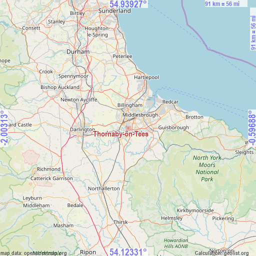
Thornaby-on-Tees GPS coordinates[2]
54° 31' 59.988" North, 1° 18' 0" West
| Map corner | latitude | longitude |
|---|---|---|
| Upper-left | 54.93927°, | -2.00313° |
| Center: | 54.53333°, | -1.3° |
| Lower-right: | 54.12331°, | -0.59688° |
| Map W x H: | 90.7×90.7 km | = 56.4×56.4mi |
| max Lat: | 60.39635° ⇑17.7% North |
| Thornaby-on-Tees: | 54.53333° |
| min Lat: | ⇓82.3% South 34.60088° |
| min Long | Thornaby-on-Tee | max Long |
| -7.64133° | -1.3° | 32.95536° |
| W 60.2%⇐ | ⇒39.8% E |
Elevation
Elevation of Thornaby-on-Tees is 20 m = 66 ft, and this is 52.9 m = 174 ft below average elevation for this country.
| Max E: |
515 m = 1690 ft | 80.8% |
| Avg. | 72.9 m = 239 ft | |
| Thornaby-on-Tees | 20 m = 66 ft | |
Min E: |
-30 m = -98 ft | 19.2% |
See also: United Kingdom elevation on elevation.city.
Geographical zone
Thornaby-on-Tees is located in North temperate zone (between Tropic of Cancer and the Arctic Circle). Distance of this North polar circle is 1337.6 km =831.1 mi to North.| Distance of | km | miles | from Thornaby-on-Tees |
|---|---|---|---|
| North Pole | 3943.5 | 2450.4 | to North |
| Arctic Circle | 1337.6 | 831.1 | to North |
| Tropic Cancer | 3457.6 | 2148.5 | to South |
| Equator | 6063.5 | 3767.7 | to South |


Nearby cities:
15 places around Thornaby-on-Tees: (largest is in red/bold)
• Billingham
6.2 km =3.9 mi,  5°
5°
• Bishopton
10.2 km =6.3 mi,  302°
302°
• Carlton
8.6 km =5.3 mi,  317°
317°
• Eaglescliffe
3.4 km =2.1 mi,  254°
254°
• Elton
4.7 km =2.9 mi,  293°
293°
• Great Ayton
11.5 km =7.1 mi,  113°
113°
• Grindon
10.7 km =6.6 mi,  329°
329°
• Kirklevington
6.1 km =3.8 mi,  202°
202°
• Middlesbrough
6.4 km =4 mi,  41°
41°
• Nunthorpe
7.5 km =4.7 mi,  93°
93°
• South Bank
10.4 km =6.5 mi,  69°
69°
• Stillington
11.2 km =7 mi, 315°
• Stockton-on-Tees
4.1 km =2.5 mi,  342°
342°
• Stokesley
9.9 km =6.2 mi,  135°
135°
• Yarm
5 km =3.1 mi,  228°
228°
Sources, notices
• [Note1] Compared only with cities in United Kingdom existing in our database
• [Src1] Map data: © OpenStreetMap contributors (CC-BY-SA)
• [Src2] Other city data from geonames.org with taken over terms of usage.
• [Src3] Geographical zone / Annual Mean Temperature by Robert A. Rohde @ Wikipedia
