Middlesbrough geodata
Middlesbrough (England) is a seat of a second-order administrative division; located in United Kingdom in Europe/London (GMT+1) time zone. With population of 142,707 people, there are 66 cities with bigger population in this country. Compared to other cities in United Kingdom, 82.8% of cities are located further ↓South; 62% of cities are located further ←West and 85.8% of cities have higher elevation than Middlesbrough. Note1


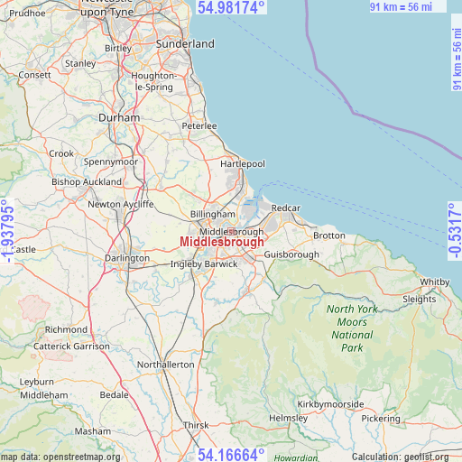
Middlesbrough GPS coordinates[2]
54° 34' 34.428" North, 1° 14' 5.388" West
| Map corner | latitude | longitude |
|---|---|---|
| Upper-left | 54.98174°, | -1.93795° |
| Center: | 54.57623°, | -1.23483° |
| Lower-right: | 54.16664°, | -0.5317° |
| Map W x H: | 90.6×90.6 km | = 56.3×56.3mi |
| max Lat: | 60.39635° ⇑17.2% North |
| Middlesbrough: | 54.57623° |
| min Lat: | ⇓82.8% South 34.60088° |
| min Long | Middlesbrough | max Long |
| -7.64133° | -1.23483° | 32.95536° |
| W 62%⇐ | ⇒38% E |
Elevation
Elevation of Middlesbrough is 15 m = 49 ft, and this is 57.9 m = 190 ft below average elevation for this country.
| Max E: |
515 m = 1690 ft | 85.8% |
| Avg. | 72.9 m = 239 ft | |
| Middlesbrough | 15 m = 49 ft | |
Min E: |
-30 m = -98 ft | 14.2% |
See also: Middlesbrough elevation on elevation.city.
Geographical zone
Middlesbrough is located in North temperate zone (between Tropic of Cancer and the Arctic Circle). Distance of this North polar circle is 1332.9 km =828.2 mi to North.| Distance of | km | miles | from Middlesbrough |
|---|---|---|---|
| North Pole | 3938.8 | 2447.5 | to North |
| Arctic Circle | 1332.9 | 828.2 | to North |
| Tropic Cancer | 3462.4 | 2151.4 | to South |
| Equator | 6068.3 | 3770.7 | to South |


Nearby cities:
15 places around Middlesbrough: (largest is in red/bold)
• Billingham
3.8 km =2.4 mi,  291°
291°
• Carlton
10.2 km =6.3 mi,  278°
278°
• Eaglescliffe
9.4 km =5.8 mi,  232°
232°
• Elton
9 km =5.6 mi,  251°
251°
• Great Ayton
11.4 km =7.1 mi,  145°
145°
• Greatham
7.3 km =4.5 mi,  358°
358°
• Grindon
10.6 km =6.6 mi,  295°
295°
• Hartlepool
12.3 km =7.6 mi,  7°
7°
• Nunthorpe
6.2 km =3.9 mi, 148°
• Redcar
12.1 km =7.5 mi,  68°
68°
• South Bank
5.6 km =3.5 mi,  101°
101°
• Stockton-on-Tees
5.5 km =3.4 mi,  260°
260°
• Stokesley
12.1 km =7.5 mi,  167°
167°
• Thornaby-on-Tees
6.4 km =4 mi,  221°
221°
• Yarm
11.3 km =7 mi, 224°
Sources, notices
• [Note1] Compared only with cities in United Kingdom existing in our database
• [Src1] Map data: © OpenStreetMap contributors (CC-BY-SA)
• [Src2] Other city data from geonames.org with taken over terms of usage.
• [Src3] Geographical zone / Annual Mean Temperature by Robert A. Rohde @ Wikipedia
