Talgarth geodata
Talgarth (Wales) is a populated place; located in United Kingdom in Europe/London (GMT+1) time zone. With population of 1,268 people, there are 3278 cities with bigger population in this country. Compared to other cities in United Kingdom, 62.2% of cities are located further ↑North; 78.8% of cities are located further →East and 83.8% of cities have lower elevation than Talgarth. Note1


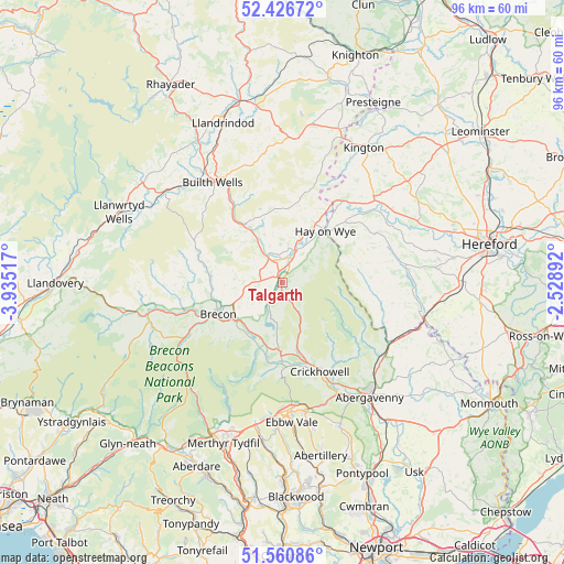
Talgarth GPS coordinates[2]
51° 59' 45.168" North, 3° 13' 55.38" West
| Map corner | latitude | longitude |
|---|---|---|
| Upper-left | 52.42672°, | -3.93517° |
| Center: | 51.99588°, | -3.23205° |
| Lower-right: | 51.56086°, | -2.52892° |
| Map W x H: | 96.3×96.3 km | = 59.8×59.8mi |
| max Lat: | 60.39635° ⇑62.2% North |
| Talgarth: | 51.99588° |
| min Lat: | ⇓37.8% South 34.60088° |
| min Long | Talgarth | max Long |
| -7.64133° | -3.23205° | 32.95536° |
| W 21.2%⇐ | ⇒78.8% E |
Elevation
Elevation of Talgarth is 129 m = 423 ft, and this is 56.1 m = 184 ft above average elevation for this country.
| Max E: |
515 m = 1690 ft | 16.2% |
| Talgarth | 129 m 423 ft | |
| Avg. | 72.9 m = 239 ft | |
Min E: |
-30 m = -98 ft | 83.8% |
See also: United Kingdom elevation on elevation.city.
Geographical zone
Talgarth is located in North temperate zone (between Tropic of Cancer and the Arctic Circle). Distance of this North polar circle is 1619.8 km =1006.5 mi to North.| Distance of | km | miles | from Talgarth |
|---|---|---|---|
| North Pole | 4225.7 | 2625.7 | to North |
| Arctic Circle | 1619.8 | 1006.5 | to North |
| Tropic Cancer | 3175.5 | 1973.2 | to South |
| Equator | 5781.4 | 3592.4 | to South |


Nearby cities:
15 places around Talgarth: (largest is in red/bold)
• Brecon
12.1 km =7.5 mi,  242°
242°
• Builth Wells
20.8 km =12.9 mi,  325°
325°
• Clifford
14.7 km =9.1 mi,  37°
37°
• Clyro
11.4 km =7.1 mi,  29°
29°
• Crickhowell
16.4 km =10.2 mi,  156°
156°
• Dorstone
17.7 km =11 mi,  63°
63°
• Gilwern
21.3 km =13.2 mi,  153°
153°
• Hay
11 km =6.8 mi, 40°
• Llangattock
17 km =10.6 mi, 160°
• Llangynidr
14.3 km =8.9 mi,  178°
178°
• Llanveynoe
16.2 km =10.1 mi,  101°
101°
• Longtown
17.8 km =11.1 mi,  106°
106°
• Moccas
21.6 km =13.4 mi,  65°
65°
• Peterchurch
19.6 km =12.2 mi, 74°
• Turnastone
19.7 km =12.2 mi,  80°
80°
Sources, notices
• [Note1] Compared only with cities in United Kingdom existing in our database
• [Src1] Map data: © OpenStreetMap contributors (CC-BY-SA)
• [Src2] Other city data from geonames.org with taken over terms of usage.
• [Src3] Geographical zone / Annual Mean Temperature by Robert A. Rohde @ Wikipedia
