Symington geodata
Symington (Scotland) is a populated place; located in United Kingdom in Europe/London (GMT+1) time zone. With population of 760 people, there are 4115 cities with bigger population in this country. Compared to other cities in United Kingdom, 89.2% of cities are located further ↓South; 83.5% of cities are located further →East and 98.1% of cities have lower elevation than Symington. Note1


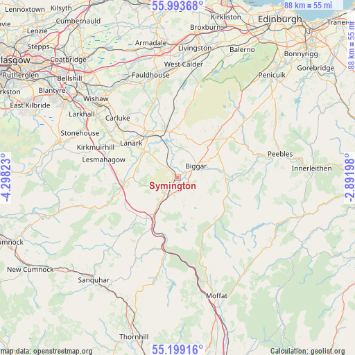
Symington GPS coordinates[2]
55° 35' 54.348" North, 3° 35' 42.36" West
| Map corner | latitude | longitude |
|---|---|---|
| Upper-left | 55.99368°, | -4.29823° |
| Center: | 55.59843°, | -3.5951° |
| Lower-right: | 55.19916°, | -2.89198° |
| Map W x H: | 88.3×88.3 km | = 54.9×54.9mi |
| max Lat: | 60.39635° ⇑10.8% North |
| Symington: | 55.59843° |
| min Lat: | ⇓89.2% South 34.60088° |
| min Long | Symington | max Long |
| -7.64133° | -3.5951° | 32.95536° |
| W 16.5%⇐ | ⇒83.5% E |
Elevation
Elevation of Symington is 226 m = 741 ft, and this is 153.1 m = 502 ft above average elevation for this country.
| Max E: |
515 m = 1690 ft | 1.9% |
| Symington | 226 m 741 ft | |
| Avg. | 72.9 m = 239 ft | |
Min E: |
-30 m = -98 ft | 98.1% |
See also: United Kingdom elevation on elevation.city.
Geographical zone
Symington is located in North temperate zone (between Tropic of Cancer and the Arctic Circle). Distance of this North polar circle is 1219.2 km =757.6 mi to North.| Distance of | km | miles | from Symington |
|---|---|---|---|
| North Pole | 3825.1 | 2376.8 | to North |
| Arctic Circle | 1219.2 | 757.6 | to North |
| Tropic Cancer | 3576 | 2222 | to South |
| Equator | 6182 | 3841.3 | to South |


Nearby cities:
15 places around Symington: (largest is in red/bold)
• Biggar
5.2 km =3.2 mi,  58°
58°
• Braidwood
19.9 km =12.4 mi,  308°
308°
• Carluke
21.2 km =13.2 mi,  316°
316°
• Carnwath
11.5 km =7.1 mi,  350°
350°
• Carstairs
12.4 km =7.7 mi,  330°
330°
• Carstairs Junction
10.7 km =6.6 mi,  336°
336°
• Coalburn
18.3 km =11.4 mi,  268°
268°
• Crossford
20.4 km =12.7 mi,  303°
303°
• Douglas
16.9 km =10.5 mi,  251°
251°
• Forth
19.4 km =12.1 mi, 342°
• Kirkfieldbank
15.7 km =9.8 mi, 302°
• Lanark
14.4 km =8.9 mi, 305°
• Lesmahagow
18.8 km =11.7 mi,  283°
283°
• Rigside
11.7 km =7.3 mi, 269°
• Thankerton
3.9 km =2.4 mi, 322°
Sources, notices
• [Note1] Compared only with cities in United Kingdom existing in our database
• [Src1] Map data: © OpenStreetMap contributors (CC-BY-SA)
• [Src2] Other city data from geonames.org with taken over terms of usage.
• [Src3] Geographical zone / Annual Mean Temperature by Robert A. Rohde @ Wikipedia
