Carnwath geodata
Carnwath (Scotland) is a populated place; located in United Kingdom in Europe/London (GMT+1) time zone. With population of 1,430 people, there are 3114 cities with bigger population in this country. Compared to other cities in United Kingdom, 90% of cities are located further ↓South; 84% of cities are located further →East and 97.8% of cities have lower elevation than Carnwath. Note1


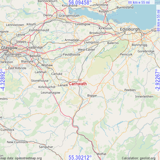
Carnwath GPS coordinates[2]
55° 42' 1.296" North, 3° 37' 32.844" West
| Map corner | latitude | longitude |
|---|---|---|
| Upper-left | 56.09458°, | -4.32892° |
| Center: | 55.70036°, | -3.62579° |
| Lower-right: | 55.30212°, | -2.92267° |
| Map W x H: | 88.1×88.1 km | = 54.7×54.7mi |
| max Lat: | 60.39635° ⇑10% North |
| Carnwath: | 55.70036° |
| min Lat: | ⇓90% South 34.60088° |
| min Long | Carnwath | max Long |
| -7.64133° | -3.62579° | 32.95536° |
| W 16%⇐ | ⇒84% E |
Elevation
Elevation of Carnwath is 218 m = 715 ft, and this is 145.1 m = 476 ft above average elevation for this country.
| Max E: |
515 m = 1690 ft | 2.2% |
| Carnwath | 218 m 715 ft | |
| Avg. | 72.9 m = 239 ft | |
Min E: |
-30 m = -98 ft | 97.8% |
See also: United Kingdom elevation on elevation.city.
Geographical zone
Carnwath is located in North temperate zone (between Tropic of Cancer and the Arctic Circle). Distance of this North polar circle is 1207.9 km =750.6 mi to North.| Distance of | km | miles | from Carnwath |
|---|---|---|---|
| North Pole | 3813.8 | 2369.8 | to North |
| Arctic Circle | 1207.9 | 750.6 | to North |
| Tropic Cancer | 3587.4 | 2229.1 | to South |
| Equator | 6193.3 | 3848.3 | to South |


Nearby cities:
15 places around Carnwath: (largest is in red/bold)
• Addiebrownhill
15.9 km =9.9 mi,  2°
2°
• Biggar
10.7 km =6.6 mi,  143°
143°
• Braidwood
13.7 km =8.5 mi,  274°
274°
• Carluke
13.4 km =8.3 mi,  287°
287°
• Carstairs
4.1 km =2.5 mi,  262°
262°
• Carstairs Junction
2.8 km =1.7 mi,  237°
237°
• Crossford
15.1 km =9.4 mi, 269°
• Fauldhouse
15 km =9.3 mi,  340°
340°
• Forth
8.2 km =5.1 mi,  331°
331°
• Kirkfieldbank
11.6 km =7.2 mi, 255°
• Lanark
10.2 km =6.3 mi,  253°
253°
• Rigside
15.1 km =9.4 mi,  220°
220°
• Stoneyburn
16 km =9.9 mi,  357°
357°
• Symington
11.5 km =7.1 mi,  170°
170°
• Thankerton
8.2 km =5.1 mi,  183°
183°
Sources, notices
• [Note1] Compared only with cities in United Kingdom existing in our database
• [Src1] Map data: © OpenStreetMap contributors (CC-BY-SA)
• [Src2] Other city data from geonames.org with taken over terms of usage.
• [Src3] Geographical zone / Annual Mean Temperature by Robert A. Rohde @ Wikipedia
