Swindon geodata
Swindon (England) is a seat of a second-order administrative division; located in United Kingdom in Europe/London (GMT+1) time zone. With population of 185,609 people, there are 43 cities with bigger population in this country. Compared to other cities in United Kingdom, 75.7% of cities are located further ↑North; 50.7% of cities are located further →East and 78.1% of cities have lower elevation than Swindon. Note1


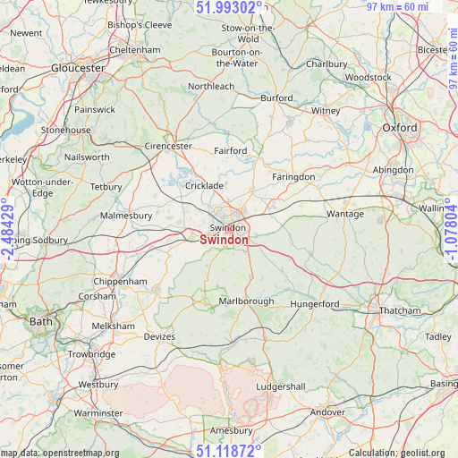
Swindon GPS coordinates[2]
51° 33' 28.692" North, 1° 46' 52.176" West
| Map corner | latitude | longitude |
|---|---|---|
| Upper-left | 51.99302°, | -2.48429° |
| Center: | 51.55797°, | -1.78116° |
| Lower-right: | 51.11872°, | -1.07804° |
| Map W x H: | 97.2×97.2 km | = 60.4×60.4mi |
| max Lat: | 60.39635° ⇑75.7% North |
| Swindon: | 51.55797° |
| min Lat: | ⇓24.3% South 34.60088° |
| min Long | Swindon | max Long |
| -7.64133° | -1.78116° | 32.95536° |
| W 49.3%⇐ | ⇒50.7% E |
Elevation
Elevation of Swindon is 113 m = 371 ft, and this is 40.1 m = 132 ft above average elevation for this country.
| Max E: |
515 m = 1690 ft | 21.9% |
| Swindon | 113 m 371 ft | |
| Avg. | 72.9 m = 239 ft | |
Min E: |
-30 m = -98 ft | 78.1% |
See also: Swindon elevation on elevation.city.
Geographical zone
Swindon is located in North temperate zone (between Tropic of Cancer and the Arctic Circle). Distance of this North polar circle is 1668.5 km =1036.8 mi to North.| Distance of | km | miles | from Swindon |
|---|---|---|---|
| North Pole | 4274.4 | 2656 | to North |
| Arctic Circle | 1668.5 | 1036.8 | to North |
| Tropic Cancer | 3126.8 | 1942.9 | to South |
| Equator | 5732.7 | 3562.1 | to South |


Nearby cities:
15 places around Swindon: (largest is in red/bold)
• Bishopstone
9.3 km =5.8 mi,  94°
94°
• Broad Blunsdon
6.2 km =3.9 mi,  1°
1°
• Broad Hinton
9 km =5.6 mi,  210°
210°
• Chiseldon
5.8 km =3.6 mi,  143°
143°
• Cricklade
10.6 km =6.6 mi,  330°
330°
• Hannington
8.7 km =5.4 mi,  14°
14°
• Highworth
9.4 km =5.8 mi,  30°
30°
• Leigh
10.5 km =6.5 mi,  308°
308°
• Lydiard Millicent
5.9 km =3.7 mi,  284°
284°
• Lydiard Tregoze
4.8 km =3 mi,  259°
259°
• Purton
7.3 km =4.5 mi,  298°
298°
• Royal Wootton Bassett
8.7 km =5.4 mi, 258°
• Shrivenham
9.8 km =6.1 mi,  62°
62°
• Wanborough
6 km =3.7 mi,  106°
106°
• Wroughton
3.9 km =2.4 mi,  194°
194°
Sources, notices
• [Note1] Compared only with cities in United Kingdom existing in our database
• [Src1] Map data: © OpenStreetMap contributors (CC-BY-SA)
• [Src2] Other city data from geonames.org with taken over terms of usage.
• [Src3] Geographical zone / Annual Mean Temperature by Robert A. Rohde @ Wikipedia
