Broad Blunsdon geodata
Broad Blunsdon (England) is a populated place; located in United Kingdom in Europe/London (GMT+1) time zone. With population of 1,803 people, there are 2773 cities with bigger population in this country. Compared to other cities in United Kingdom, 73.9% of cities are located further ↑North; 50.6% of cities are located further →East and 87.9% of cities have lower elevation than Broad Blunsdon. Note1
Administrative division(s):
- Level 1: England
- Level 2: Borough of Swindon
- Level 3: Blunsdon St. Andrew


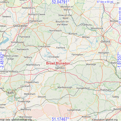
Broad Blunsdon GPS coordinates[2]
51° 36' 48.204" North, 1° 46' 43.32" West
| Map corner | latitude | longitude |
|---|---|---|
| Upper-left | 52.04791°, | -2.48182° |
| Center: | 51.61339°, | -1.7787° |
| Lower-right: | 51.17467°, | -1.07557° |
| Map W x H: | 97.1×97.1 km | = 60.3×60.3mi |
| max Lat: | 60.39635° ⇑73.9% North |
| Broad Blunsdon: | 51.61339° |
| min Lat: | ⇓26.1% South 34.60088° |
| min Long | Broad Blunsdon | max Long |
| -7.64133° | -1.7787° | 32.95536° |
| W 49.4%⇐ | ⇒50.6% E |
Elevation
Elevation of Broad Blunsdon is 142 m = 466 ft, and this is 69.1 m = 227 ft above average elevation for this country.
| Max E: |
515 m = 1690 ft | 12.1% |
| Broad Blunsdon | 142 m 466 ft | |
| Avg. | 72.9 m = 239 ft | |
Min E: |
-30 m = -98 ft | 87.9% |
See also: United Kingdom elevation on elevation.city.
Geographical zone
Broad Blunsdon is located in North temperate zone (between Tropic of Cancer and the Arctic Circle). Distance of this North polar circle is 1662.3 km =1032.9 mi to North.| Distance of | km | miles | from Broad Blunsdon |
|---|---|---|---|
| North Pole | 4268.2 | 2652.1 | to North |
| Arctic Circle | 1662.3 | 1032.9 | to North |
| Tropic Cancer | 3133 | 1946.8 | to South |
| Equator | 5738.9 | 3566 | to South |


Nearby cities:
15 places around Broad Blunsdon: (largest is in red/bold)
• Cricklade
6.2 km =3.9 mi,  299°
299°
• Down Ampney
8.6 km =5.3 mi,  321°
321°
• Fairford
10.5 km =6.5 mi,  359°
359°
• Hannington
3 km =1.9 mi,  41°
41°
• Highworth
5 km =3.1 mi,  67°
67°
• Latton
8.1 km =5 mi,  308°
308°
• Lechlade
10.8 km =6.7 mi,  33°
33°
• Leigh
8.4 km =5.2 mi,  272°
272°
• Lydiard Millicent
7.5 km =4.7 mi,  231°
231°
• Lydiard Tregoze
8.6 km =5.3 mi,  214°
214°
• Purton
7.1 km =4.4 mi,  247°
247°
• Shrivenham
8.7 km =5.4 mi,  100°
100°
• Swindon
6.2 km =3.9 mi,  181°
181°
• Wanborough
9.6 km =6 mi,  144°
144°
• Wroughton
10 km =6.2 mi,  186°
186°
Sources, notices
• [Note1] Compared only with cities in United Kingdom existing in our database
• [Src1] Map data: © OpenStreetMap contributors (CC-BY-SA)
• [Src2] Other city data from geonames.org with taken over terms of usage.
• [Src3] Geographical zone / Annual Mean Temperature by Robert A. Rohde @ Wikipedia
