Stokenchurch geodata
Stokenchurch (England) is a populated place; located in United Kingdom in Europe/London (GMT+1) time zone. With population of 4,056 people, there are 1825 cities with bigger population in this country. Compared to other cities in United Kingdom, 72.4% of cities are located further ↑North; 68.5% of cities are located further ←West and 98% of cities have lower elevation than Stokenchurch. Note1
Administrative division(s):
- Level 1: England
- Level 2: Buckinghamshire
- Level 3: Wycombe
- Level 4: Stokenchurch


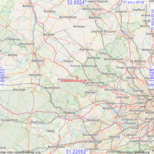
Stokenchurch GPS coordinates[2]
51° 39' 29.916" North, 0° 53' 50.64" West
| Map corner | latitude | longitude |
|---|---|---|
| Upper-left | 52.0924°, | -1.60053° |
| Center: | 51.65831°, | -0.8974° |
| Lower-right: | 51.22002°, | -0.19428° |
| Map W x H: | 97×97 km | = 60.3×60.3mi |
| max Lat: | 60.39635° ⇑72.4% North |
| Stokenchurch: | 51.65831° |
| min Lat: | ⇓27.6% South 34.60088° |
| min Long | Stokenchurch | max Long |
| -7.64133° | -0.8974° | 32.95536° |
| W 68.5%⇐ | ⇒31.5% E |
Elevation
Elevation of Stokenchurch is 223 m = 732 ft, and this is 150.1 m = 492 ft above average elevation for this country.
| Max E: |
515 m = 1690 ft | 2% |
| Stokenchurch | 223 m 732 ft | |
| Avg. | 72.9 m = 239 ft | |
Min E: |
-30 m = -98 ft | 98% |
See also: United Kingdom elevation on elevation.city.
Geographical zone
Stokenchurch is located in North temperate zone (between Tropic of Cancer and the Arctic Circle). Distance of this North polar circle is 1657.3 km =1029.8 mi to North.| Distance of | km | miles | from Stokenchurch |
|---|---|---|---|
| North Pole | 4263.2 | 2649 | to North |
| Arctic Circle | 1657.3 | 1029.8 | to North |
| Tropic Cancer | 3137.9 | 1949.8 | to South |
| Equator | 5743.9 | 3569.1 | to South |


Nearby cities:
15 places around Stokenchurch: (largest is in red/bold)
• Chalgrove
12.4 km =7.7 mi,  273°
273°
• Chinnor
4.9 km =3 mi,  348°
348°
• Ellesborough
12.8 km =8 mi,  35°
35°
• Frieth
6.7 km =4.2 mi,  152°
152°
• Great Kimble
11.6 km =7.2 mi,  31°
31°
• Haddenham
12.9 km =8 mi, 351°
• High Wycombe
10.7 km =6.6 mi,  107°
107°
• Kingston Blount
4.2 km =2.6 mi,  325°
325°
• Longwick
9.1 km =5.7 mi,  17°
17°
• Nettlebed
11.2 km =7 mi,  214°
214°
• Princes Risborough
8.7 km =5.4 mi, 31°
• Remenham
11.8 km =7.3 mi,  177°
177°
• Tetsworth
9.4 km =5.8 mi,  307°
307°
• Thame
11.4 km =7.1 mi, 331°
• Watlington
7.6 km =4.7 mi,  257°
257°
Sources, notices
• [Note1] Compared only with cities in United Kingdom existing in our database
• [Src1] Map data: © OpenStreetMap contributors (CC-BY-SA)
• [Src2] Other city data from geonames.org with taken over terms of usage.
• [Src3] Geographical zone / Annual Mean Temperature by Robert A. Rohde @ Wikipedia
