Stafford geodata
Stafford (England) is a seat of a second-order administrative division; located in United Kingdom in Europe/London (GMT+1) time zone. With population of 69,217 people, there are 153 cities with bigger population in this country. Compared to other cities in United Kingdom, 57.4% of cities are located further ↓South; 57% of cities are located further →East and 60.3% of cities have lower elevation than Stafford. Note1


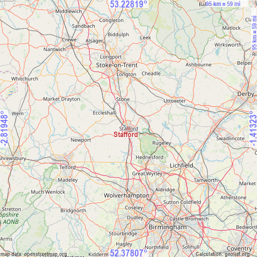
Stafford GPS coordinates[2]
52° 48' 18.756" North, 2° 6' 58.896" West
| Map corner | latitude | longitude |
|---|---|---|
| Upper-left | 53.22819°, | -2.81948° |
| Center: | 52.80521°, | -2.11636° |
| Lower-right: | 52.37807°, | -1.41323° |
| Map W x H: | 94.5×94.5 km | = 58.7×58.7mi |
| max Lat: | 60.39635° ⇑42.6% North |
| Stafford: | 52.80521° |
| min Lat: | ⇓57.4% South 34.60088° |
| min Long | Stafford | max Long |
| -7.64133° | -2.11636° | 32.95536° |
| W 43%⇐ | ⇒57% E |
Elevation
Elevation of Stafford is 77 m = 253 ft, and this is 4.1 m = 13 ft above average elevation for this country.
| Max E: |
515 m = 1690 ft | 39.7% |
| Stafford | 77 m 253 ft | |
| Avg. | 72.9 m = 239 ft | |
Min E: |
-30 m = -98 ft | 60.3% |
See also: Stafford elevation on elevation.city.
Geographical zone
Stafford is located in North temperate zone (between Tropic of Cancer and the Arctic Circle). Distance of this North polar circle is 1529.8 km =950.6 mi to North.| Distance of | km | miles | from Stafford |
|---|---|---|---|
| North Pole | 4135.7 | 2569.8 | to North |
| Arctic Circle | 1529.8 | 950.6 | to North |
| Tropic Cancer | 3265.5 | 2029.1 | to South |
| Equator | 5871.4 | 3648.3 | to South |


Nearby cities:
15 places around Stafford: (largest is in red/bold)
• Acton Trussell
5.1 km =3.2 mi,  165°
165°
• Bradley
6.7 km =4.2 mi,  219°
219°
• Brewood
14.8 km =9.2 mi,  195°
195°
• Cannock
14 km =8.7 mi,  155°
155°
• Colwich
9.2 km =5.7 mi,  102°
102°
• Derrington
3.2 km =2 mi,  261°
261°
• Eccleshall
10.7 km =6.6 mi,  303°
303°
• Fulford
15.1 km =9.4 mi,  11°
11°
• Gnosall
9.6 km =6 mi, 256°
• Great Haywood
7.8 km =4.8 mi,  87°
87°
• Haughton
6.1 km =3.8 mi,  246°
246°
• Penkridge
8.9 km =5.5 mi,  179°
179°
• Rugeley
13.1 km =8.1 mi,  112°
112°
• Stone
11.5 km =7.1 mi,  347°
347°
• Wheaton Aston
12.6 km =7.8 mi,  213°
213°
Sources, notices
• [Note1] Compared only with cities in United Kingdom existing in our database
• [Src1] Map data: © OpenStreetMap contributors (CC-BY-SA)
• [Src2] Other city data from geonames.org with taken over terms of usage.
• [Src3] Geographical zone / Annual Mean Temperature by Robert A. Rohde @ Wikipedia
