Slough geodata
Slough (England) is a seat of a second-order administrative division; located in United Kingdom in Europe/London (GMT+1) time zone. With population of 163,777 people, there are 52 cities with bigger population in this country. Compared to other cities in United Kingdom, 77.4% of cities are located further ↑North; 74.7% of cities are located further ←West and 70% of cities have higher elevation than Slough. Note1


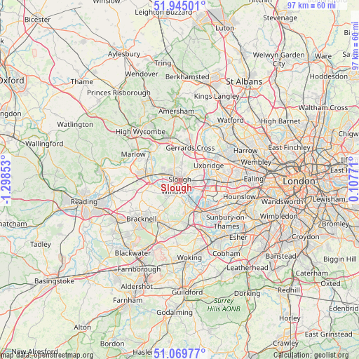
Slough GPS coordinates[2]
51° 30' 34.164" North, 0° 35' 43.476" West
| Map corner | latitude | longitude |
|---|---|---|
| Upper-left | 51.94501°, | -1.29853° |
| Center: | 51.50949°, | -0.59541° |
| Lower-right: | 51.06977°, | 0.10771° |
| Map W x H: | 97.3×97.3 km | = 60.5×60.5mi |
| max Lat: | 60.39635° ⇑77.4% North |
| Slough: | 51.50949° |
| min Lat: | ⇓22.6% South 34.60088° |
| min Long | Slough | max Long |
| -7.64133° | -0.59541° | 32.95536° |
| W 74.7%⇐ | ⇒25.3% E |
Elevation
Elevation of Slough is 33 m = 108 ft, and this is 39.9 m = 131 ft below average elevation for this country.
| Max E: |
515 m = 1690 ft | 70% |
| Avg. | 72.9 m = 239 ft | |
| Slough | 33 m = 108 ft | |
Min E: |
-30 m = -98 ft | 30% |
See also: Slough elevation on elevation.city.
Geographical zone
Slough is located in North temperate zone (between Tropic of Cancer and the Arctic Circle). Distance of this North polar circle is 1673.9 km =1040.1 mi to North.| Distance of | km | miles | from Slough |
|---|---|---|---|
| North Pole | 4279.7 | 2659.3 | to North |
| Arctic Circle | 1673.9 | 1040.1 | to North |
| Tropic Cancer | 3121.4 | 1939.5 | to South |
| Equator | 5727.3 | 3558.8 | to South |


Nearby cities:
15 places around Slough: (largest is in red/bold)
• Bray
6.4 km =4 mi,  263°
263°
• Colnbrook
5.9 km =3.7 mi,  119°
119°
• Datchet
3.1 km =1.9 mi,  158°
158°
• Eton
2.5 km =1.6 mi,  201°
201°
• Eton Wick
3 km =1.9 mi,  243°
243°
• Farnham Royal
3.9 km =2.4 mi,  338°
338°
• Gerrards Cross
9 km =5.6 mi,  17°
17°
• Harmondsworth
8.5 km =5.3 mi,  106°
106°
• Horton
5.5 km =3.4 mi,  137°
137°
• Iver
6.7 km =4.2 mi,  99°
99°
• Iver Heath
6.1 km =3.8 mi,  60°
60°
• Maidenhead
8.7 km =5.4 mi,  279°
279°
• Old Windsor
5.7 km =3.5 mi,  174°
174°
• Stoke Poges
3.9 km =2.4 mi,  6°
6°
• Windsor
2.9 km =1.8 mi,  186°
186°
Sources, notices
• [Note1] Compared only with cities in United Kingdom existing in our database
• [Src1] Map data: © OpenStreetMap contributors (CC-BY-SA)
• [Src2] Other city data from geonames.org with taken over terms of usage.
• [Src3] Geographical zone / Annual Mean Temperature by Robert A. Rohde @ Wikipedia
