Maidenhead geodata
Maidenhead (England) is a seat of a second-order administrative division; located in United Kingdom in Europe/London (GMT+1) time zone. With population of 64,831 people, there are 162 cities with bigger population in this country. Compared to other cities in United Kingdom, 77% of cities are located further ↑North; 71.9% of cities are located further ←West and 70.9% of cities have higher elevation than Maidenhead. Note1


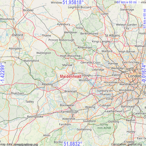
Maidenhead GPS coordinates[2]
51° 31' 22.044" North, 0° 43' 11.496" West
| Map corner | latitude | longitude |
|---|---|---|
| Upper-left | 51.95818°, | -1.42299° |
| Center: | 51.52279°, | -0.71986° |
| Lower-right: | 51.0832°, | -0.01674° |
| Map W x H: | 97.3×97.3 km | = 60.5×60.5mi |
| max Lat: | 60.39635° ⇑77% North |
| Maidenhead: | 51.52279° |
| min Lat: | ⇓23% South 34.60088° |
| min Long | Maidenhead | max Long |
| -7.64133° | -0.71986° | 32.95536° |
| W 71.9%⇐ | ⇒28.1% E |
Elevation
Elevation of Maidenhead is 32 m = 105 ft, and this is 40.9 m = 134 ft below average elevation for this country.
| Max E: |
515 m = 1690 ft | 70.9% |
| Avg. | 72.9 m = 239 ft | |
| Maidenhead | 32 m = 105 ft | |
Min E: |
-30 m = -98 ft | 29.1% |
See also: Maidenhead elevation on elevation.city.
Geographical zone
Maidenhead is located in North temperate zone (between Tropic of Cancer and the Arctic Circle). Distance of this North polar circle is 1672.4 km =1039.2 mi to North.| Distance of | km | miles | from Maidenhead |
|---|---|---|---|
| North Pole | 4278.3 | 2658.4 | to North |
| Arctic Circle | 1672.4 | 1039.2 | to North |
| Tropic Cancer | 3122.9 | 1940.5 | to South |
| Equator | 5728.8 | 3559.7 | to South |


Nearby cities:
15 places around Maidenhead: (largest is in red/bold)
• Bisham
5.8 km =3.6 mi,  316°
316°
• Bourne End
6 km =3.7 mi,  4°
4°
• Bray
3.1 km =1.9 mi,  134°
134°
• Cookham
4.1 km =2.5 mi,  11°
11°
• Eton
8.6 km =5.3 mi,  116°
116°
• Eton Wick
6.6 km =4.1 mi, 115°
• Farnham Royal
7.5 km =4.7 mi,  73°
73°
• Hurley
6.7 km =4.2 mi,  293°
293°
• Knowl Hill
7 km =4.3 mi,  255°
255°
• Marlow
6.4 km =4 mi, 324°
• Slough
8.7 km =5.4 mi,  99°
99°
• Stoke Poges
9.4 km =5.8 mi,  75°
75°
• Waltham St Lawrence
7.3 km =4.5 mi,  235°
235°
• Warfield
9 km =5.6 mi,  183°
183°
• White Waltham
5 km =3.1 mi,  226°
226°
Sources, notices
• [Note1] Compared only with cities in United Kingdom existing in our database
• [Src1] Map data: © OpenStreetMap contributors (CC-BY-SA)
• [Src2] Other city data from geonames.org with taken over terms of usage.
• [Src3] Geographical zone / Annual Mean Temperature by Robert A. Rohde @ Wikipedia
