Skelmorlie geodata
Skelmorlie (Scotland) is a populated place; located in United Kingdom in Europe/London (GMT+1) time zone. With population of 1,990 people, there are 2633 cities with bigger population in this country. Compared to other cities in United Kingdom, 91.9% of cities are located further ↓South; 95.6% of cities are located further →East and 51.8% of cities have lower elevation than Skelmorlie. Note1


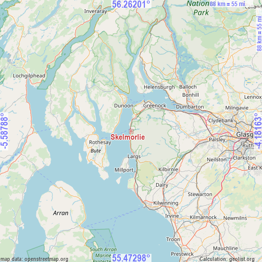
Skelmorlie GPS coordinates[2]
55° 52' 10.2" North, 4° 53' 5.1" West
| Map corner | latitude | longitude |
|---|---|---|
| Upper-left | 56.26201°, | -5.58788° |
| Center: | 55.8695°, | -4.88475° |
| Lower-right: | 55.47298°, | -4.18163° |
| Map W x H: | 87.7×87.7 km | = 54.5×54.5mi |
| max Lat: | 60.39635° ⇑8.1% North |
| Skelmorlie: | 55.8695° |
| min Lat: | ⇓91.9% South 34.60088° |
| min Long | Skelmorlie | max Long |
| -7.64133° | -4.88475° | 32.95536° |
| W 4.4%⇐ | ⇒95.6% E |
Elevation
Elevation of Skelmorlie is 63 m = 207 ft, and this is 9.9 m = 32 ft below average elevation for this country.
| Max E: |
515 m = 1690 ft | 48.2% |
| Avg. | 72.9 m = 239 ft | |
| Skelmorlie | 63 m = 207 ft | |
Min E: |
-30 m = -98 ft | 51.8% |
See also: United Kingdom elevation on elevation.city.
Geographical zone
Skelmorlie is located in North temperate zone (between Tropic of Cancer and the Arctic Circle). Distance of this North polar circle is 1189.1 km =738.9 mi to North.| Distance of | km | miles | from Skelmorlie |
|---|---|---|---|
| North Pole | 3795 | 2358.1 | to North |
| Arctic Circle | 1189.1 | 738.9 | to North |
| Tropic Cancer | 3606.2 | 2240.8 | to South |
| Equator | 6212.1 | 3860 | to South |


Nearby cities:
15 places around Skelmorlie: (largest is in red/bold)
• Dunoon
9.4 km =5.8 mi,  343°
343°
• Fairlie
12.7 km =7.9 mi,  171°
171°
• Gourock
11.1 km =6.9 mi,  22°
22°
• Greenock
11.7 km =7.3 mi,  41°
41°
• Innellan
5.4 km =3.4 mi,  297°
297°
• Inverkip
4.4 km =2.7 mi,  11°
11°
• Isle of Bute
11.3 km =7 mi,  251°
251°
• Isle of Cumbrae
11.3 km =7 mi,  190°
190°
• Largs
8.2 km =5.1 mi, 170°
• Millport
13.2 km =8.2 mi, 191°
• Port Bannatyne
11.3 km =7 mi,  262°
262°
• Rothesay
11.2 km =7 mi, 250°
• Sandbank
13.2 km =8.2 mi, 342°
• Strone
13 km =8.1 mi,  354°
354°
• Wemyss Bay
0.8 km =0.5 mi, 338°
Sources, notices
• [Note1] Compared only with cities in United Kingdom existing in our database
• [Src1] Map data: © OpenStreetMap contributors (CC-BY-SA)
• [Src2] Other city data from geonames.org with taken over terms of usage.
• [Src3] Geographical zone / Annual Mean Temperature by Robert A. Rohde @ Wikipedia
