Shirebrook geodata
Shirebrook (England) is a populated place; located in United Kingdom in Europe/London (GMT+1) time zone. With population of 10,885 people, there are 991 cities with bigger population in this country. Compared to other cities in United Kingdom, 64% of cities are located further ↓South; 62.4% of cities are located further ←West and 65.3% of cities have lower elevation than Shirebrook. Note1
Administrative division(s):
- Level 1: England
- Level 2: Derbyshire
- Level 3: Bolsover District
- Level 4: Shirebrook


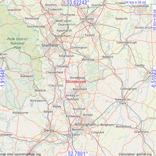
Shirebrook GPS coordinates[2]
53° 12' 11.988" North, 1° 12' 48.096" West
| Map corner | latitude | longitude |
|---|---|---|
| Upper-left | 53.62242°, | -1.91648° |
| Center: | 53.20333°, | -1.21336° |
| Lower-right: | 52.7801°, | -0.51023° |
| Map W x H: | 93.7×93.7 km | = 58.2×58.2mi |
| max Lat: | 60.39635° ⇑36% North |
| Shirebrook: | 53.20333° |
| min Lat: | ⇓64% South 34.60088° |
| min Long | Shirebrook | max Long |
| -7.64133° | -1.21336° | 32.95536° |
| W 62.4%⇐ | ⇒37.6% E |
Elevation
Elevation of Shirebrook is 87 m = 285 ft, and this is 14.1 m = 46 ft above average elevation for this country.
| Max E: |
515 m = 1690 ft | 34.7% |
| Shirebrook | 87 m 285 ft | |
| Avg. | 72.9 m = 239 ft | |
Min E: |
-30 m = -98 ft | 65.3% |
See also: United Kingdom elevation on elevation.city.
Geographical zone
Shirebrook is located in North temperate zone (between Tropic of Cancer and the Arctic Circle). Distance of this North polar circle is 1485.5 km =923 mi to North.| Distance of | km | miles | from Shirebrook |
|---|---|---|---|
| North Pole | 4091.4 | 2542.3 | to North |
| Arctic Circle | 1485.5 | 923 | to North |
| Tropic Cancer | 3309.7 | 2056.6 | to South |
| Equator | 5915.7 | 3675.8 | to South |


Nearby cities:
15 places around Shirebrook: (largest is in red/bold)
• Barlborough
10.6 km =6.6 mi,  332°
332°
• Bolsover
5.9 km =3.7 mi,  298°
298°
• Clowne
8.6 km =5.3 mi,  336°
336°
• Creswell
6.6 km =4.1 mi,  356°
356°
• Edwinstowe
10 km =6.2 mi,  95°
95°
• Glapwell
4.9 km =3 mi,  251°
251°
• King's Clipstone
8 km =5 mi,  111°
111°
• Mansfield
7.8 km =4.8 mi,  173°
173°
• Mansfield Woodhouse
4.5 km =2.8 mi,  163°
163°
• Market Warsop
4.1 km =2.5 mi,  87°
87°
• Sutton in Ashfield
9.2 km =5.7 mi,  200°
200°
• Tibshelf
10.7 km =6.6 mi,  232°
232°
• Upper Langwith
2.9 km =1.8 mi,  8°
8°
• Warsop
4.3 km =2.7 mi,  74°
74°
• Whitwell
8.9 km =5.5 mi, 358°
Sources, notices
• [Note1] Compared only with cities in United Kingdom existing in our database
• [Src1] Map data: © OpenStreetMap contributors (CC-BY-SA)
• [Src2] Other city data from geonames.org with taken over terms of usage.
• [Src3] Geographical zone / Annual Mean Temperature by Robert A. Rohde @ Wikipedia
