Mansfield geodata
Mansfield (England) is a populated place; located in United Kingdom in Europe/London (GMT+1) time zone. With population of 171,958 people, there are 49 cities with bigger population in this country. Compared to other cities in United Kingdom, 62.7% of cities are located further ↓South; 62.7% of cities are located further ←West and 81.6% of cities have lower elevation than Mansfield. Note1


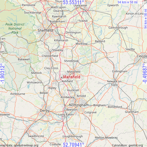
Mansfield GPS coordinates[2]
53° 7' 59.988" North, 1° 12' 0" West
| Map corner | latitude | longitude |
|---|---|---|
| Upper-left | 53.55311°, | -1.90312° |
| Center: | 53.13333°, | -1.2° |
| Lower-right: | 52.70941°, | -0.49687° |
| Map W x H: | 93.8×93.8 km | = 58.3×58.3mi |
| max Lat: | 60.39635° ⇑37.3% North |
| Mansfield: | 53.13333° |
| min Lat: | ⇓62.7% South 34.60088° |
| min Long | Mansfield | max Long |
| -7.64133° | -1.2° | 32.95536° |
| W 62.7%⇐ | ⇒37.3% E |
Elevation
Elevation of Mansfield is 122 m = 400 ft, and this is 49.1 m = 161 ft above average elevation for this country.
| Max E: |
515 m = 1690 ft | 18.4% |
| Mansfield | 122 m 400 ft | |
| Avg. | 72.9 m = 239 ft | |
Min E: |
-30 m = -98 ft | 81.6% |
See also: Mansfield elevation on elevation.city.
Geographical zone
Mansfield is located in North temperate zone (between Tropic of Cancer and the Arctic Circle). Distance of this North polar circle is 1493.3 km =927.9 mi to North.| Distance of | km | miles | from Mansfield |
|---|---|---|---|
| North Pole | 4099.2 | 2547.1 | to North |
| Arctic Circle | 1493.3 | 927.9 | to North |
| Tropic Cancer | 3302 | 2051.8 | to South |
| Equator | 5907.9 | 3671 | to South |


Nearby cities:
15 places around Mansfield: (largest is in red/bold)
• Blackwell
9.1 km =5.7 mi,  258°
258°
• Blidworth
6.8 km =4.2 mi,  124°
124°
• Glapwell
8.3 km =5.2 mi,  318°
318°
• King's Clipstone
8.2 km =5.1 mi,  53°
53°
• Kirkby in Ashfield
4.7 km =2.9 mi,  218°
218°
• Mansfield Woodhouse
3.5 km =2.2 mi,  6°
6°
• Market Warsop
8.6 km =5.3 mi,  21°
21°
• Pinxton
9.2 km =5.7 mi,  238°
238°
• Rainworth
5.7 km =3.5 mi,  106°
106°
• Ravenshead
5.8 km =3.6 mi,  153°
153°
• Shirebrook
7.8 km =4.8 mi,  353°
353°
• Sutton in Ashfield
4.2 km =2.6 mi, 257°
• Tibshelf
9.5 km =5.9 mi,  277°
277°
• Upper Langwith
10.7 km =6.6 mi,  357°
357°
• Warsop
9.5 km =5.9 mi, 20°
Sources, notices
• [Note1] Compared only with cities in United Kingdom existing in our database
• [Src1] Map data: © OpenStreetMap contributors (CC-BY-SA)
• [Src2] Other city data from geonames.org with taken over terms of usage.
• [Src3] Geographical zone / Annual Mean Temperature by Robert A. Rohde @ Wikipedia
