Sheringham geodata
Sheringham (England) is a populated place; located in United Kingdom in Europe/London (GMT+1) time zone. With population of 8,090 people, there are 1218 cities with bigger population in this country. Compared to other cities in United Kingdom, 59.7% of cities are located further ↓South; 97.7% of cities are located further ←West and 75.4% of cities have higher elevation than Sheringham. Note1
Administrative division(s):
- Level 1: England
- Level 2: Norfolk
- Level 3: North Norfolk District
- Level 4: Sheringham


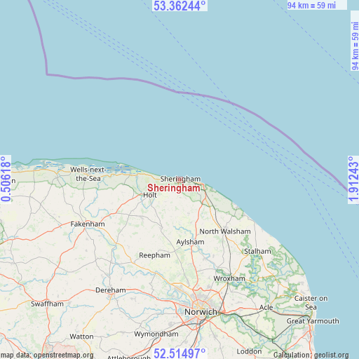
Sheringham GPS coordinates[2]
52° 56' 26.808" North, 1° 12' 33.516" East
| Map corner | latitude | longitude |
|---|---|---|
| Upper-left | 53.36244°, | 0.50618° |
| Center: | 52.94078°, | 1.20931° |
| Lower-right: | 52.51497°, | 1.91243° |
| Map W x H: | 94.2×94.2 km | = 58.5×58.5mi |
| max Lat: | 60.39635° ⇑40.3% North |
| Sheringham: | 52.94078° |
| min Lat: | ⇓59.7% South 34.60088° |
| min Long | Sheringham | max Long |
| -7.64133° | 1.20931° | 32.95536° |
| W 97.7%⇐ | ⇒2.3% E |
Elevation
Elevation of Sheringham is 26 m = 85 ft, and this is 46.9 m = 154 ft below average elevation for this country.
| Max E: |
515 m = 1690 ft | 75.4% |
| Avg. | 72.9 m = 239 ft | |
| Sheringham | 26 m = 85 ft | |
Min E: |
-30 m = -98 ft | 24.6% |
See also: United Kingdom elevation on elevation.city.
Geographical zone
Sheringham is located in North temperate zone (between Tropic of Cancer and the Arctic Circle). Distance of this North polar circle is 1514.7 km =941.2 mi to North.| Distance of | km | miles | from Sheringham |
|---|---|---|---|
| North Pole | 4120.6 | 2560.4 | to North |
| Arctic Circle | 1514.7 | 941.2 | to North |
| Tropic Cancer | 3280.5 | 2038.4 | to South |
| Equator | 5886.5 | 3657.7 | to South |


Nearby cities:
15 places around Sheringham: (largest is in red/bold)
• Aylsham
16.3 km =10.1 mi,  170°
170°
• Briston
14 km =8.7 mi,  226°
226°
• Cawston
19.6 km =12.2 mi,  188°
188°
• Corpusty
13.5 km =8.4 mi,  201°
201°
• Cromer
6.1 km =3.8 mi,  100°
100°
• Hindolveston
18.2 km =11.3 mi,  224°
224°
• Holt
9 km =5.6 mi,  244°
244°
• Marsham
19.3 km =12 mi, 171°
• Mundesley
16.3 km =10.1 mi,  115°
115°
• North Walsham
17.9 km =11.1 mi,  138°
138°
• Overstrand
9.1 km =5.7 mi,  107°
107°
• Roughton
8.8 km =5.5 mi, 136°
• Trunch
15.3 km =9.5 mi, 124°
• West Runton
2.3 km =1.4 mi, 98°
• Weybourne
4.6 km =2.9 mi,  272°
272°
Sources, notices
• [Note1] Compared only with cities in United Kingdom existing in our database
• [Src1] Map data: © OpenStreetMap contributors (CC-BY-SA)
• [Src2] Other city data from geonames.org with taken over terms of usage.
• [Src3] Geographical zone / Annual Mean Temperature by Robert A. Rohde @ Wikipedia
