Briston geodata
Briston (England) is a populated place; located in United Kingdom in Europe/London (GMT+1) time zone. With population of 3,057 people, there are 2104 cities with bigger population in this country. Compared to other cities in United Kingdom, 58.2% of cities are located further ↓South; 96.8% of cities are located further ←West and 53% of cities have higher elevation than Briston. Note1
Administrative division(s):
- Level 1: England
- Level 2: Norfolk
- Level 3: North Norfolk District
- Level 4: Briston


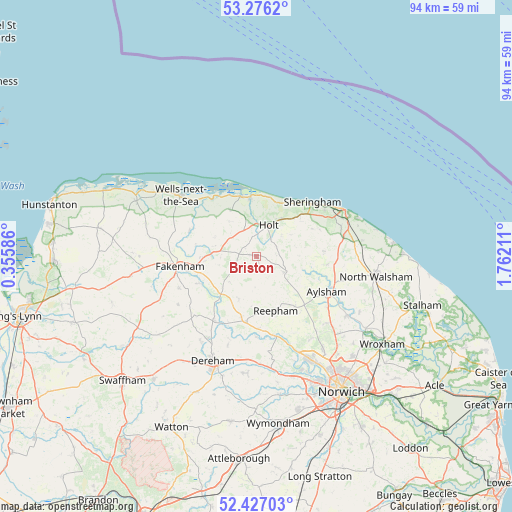
Briston GPS coordinates[2]
52° 51' 13.284" North, 1° 3' 32.364" East
| Map corner | latitude | longitude |
|---|---|---|
| Upper-left | 53.2762°, | 0.35586° |
| Center: | 52.85369°, | 1.05899° |
| Lower-right: | 52.42703°, | 1.76211° |
| Map W x H: | 94.4×94.4 km | = 58.7×58.7mi |
| max Lat: | 60.39635° ⇑41.8% North |
| Briston: | 52.85369° |
| min Lat: | ⇓58.2% South 34.60088° |
| min Long | Briston | max Long |
| -7.64133° | 1.05899° | 32.95536° |
| W 96.8%⇐ | ⇒3.2% E |
Elevation
Elevation of Briston is 56 m = 184 ft, and this is 16.9 m = 55 ft below average elevation for this country.
| Max E: |
515 m = 1690 ft | 53% |
| Avg. | 72.9 m = 239 ft | |
| Briston | 56 m = 184 ft | |
Min E: |
-30 m = -98 ft | 47% |
See also: United Kingdom elevation on elevation.city.
Geographical zone
Briston is located in North temperate zone (between Tropic of Cancer and the Arctic Circle). Distance of this North polar circle is 1524.4 km =947.2 mi to North.| Distance of | km | miles | from Briston |
|---|---|---|---|
| North Pole | 4130.3 | 2566.4 | to North |
| Arctic Circle | 1524.4 | 947.2 | to North |
| Tropic Cancer | 3270.9 | 2032.4 | to South |
| Equator | 5876.8 | 3651.7 | to South |


Nearby cities:
15 places around Briston: (largest is in red/bold)
• Aylsham
14.4 km =8.9 mi,  116°
116°
• Bawdeswell
12.2 km =7.6 mi,  189°
189°
• Cawston
12.1 km =7.5 mi,  143°
143°
• Corpusty
5.9 km =3.7 mi, 119°
• Fakenham
14.4 km =8.9 mi,  259°
259°
• Foulsham
8.6 km =5.3 mi,  202°
202°
• Great Ryburgh
11.8 km =7.3 mi,  244°
244°
• Hindolveston
4.3 km =2.7 mi,  217°
217°
• Holt
6.1 km =3.8 mi,  18°
18°
• Little Walsingham
13.3 km =8.3 mi,  290°
290°
• Lyng
15.2 km =9.4 mi,  178°
178°
• North Elmham
14.1 km =8.8 mi,  212°
212°
• Reepham
10.7 km =6.6 mi,  160°
160°
• Sheringham
14 km =8.7 mi,  46°
46°
• Weybourne
11.3 km =7 mi,  28°
28°
Sources, notices
• [Note1] Compared only with cities in United Kingdom existing in our database
• [Src1] Map data: © OpenStreetMap contributors (CC-BY-SA)
• [Src2] Other city data from geonames.org with taken over terms of usage.
• [Src3] Geographical zone / Annual Mean Temperature by Robert A. Rohde @ Wikipedia
