Sheffield geodata
Sheffield (England) is a seat of a second-order administrative division; located in United Kingdom in Europe/London (GMT+1) time zone. With population of 685,368 people, there are 4 cities with bigger population in this country. Compared to other cities in United Kingdom, 67.5% of cities are located further ↓South; 56.2% of cities are located further ←West and 59% of cities have lower elevation than Sheffield. Note1


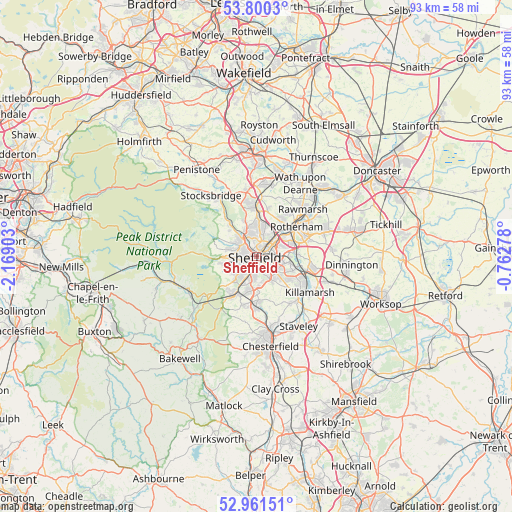
Sheffield GPS coordinates[2]
53° 22' 58.692" North, 1° 27' 57.24" West
| Map corner | latitude | longitude |
|---|---|---|
| Upper-left | 53.8003°, | -2.16903° |
| Center: | 53.38297°, | -1.4659° |
| Lower-right: | 52.96151°, | -0.76278° |
| Map W x H: | 93.3×93.3 km | = 58×58mi |
| max Lat: | 60.39635° ⇑32.5% North |
| Sheffield: | 53.38297° |
| min Lat: | ⇓67.5% South 34.60088° |
| min Long | Sheffield | max Long |
| -7.64133° | -1.4659° | 32.95536° |
| W 56.2%⇐ | ⇒43.8% E |
Elevation
Elevation of Sheffield is 75 m = 246 ft, and this is 2.1 m = 7 ft above average elevation for this country.
| Max E: |
515 m = 1690 ft | 41% |
| Sheffield | 75 m 246 ft | |
| Avg. | 72.9 m = 239 ft | |
Min E: |
-30 m = -98 ft | 59% |
See also: Sheffield elevation on elevation.city.
Geographical zone
Sheffield is located in North temperate zone (between Tropic of Cancer and the Arctic Circle). Distance of this North polar circle is 1465.5 km =910.6 mi to North.| Distance of | km | miles | from Sheffield |
|---|---|---|---|
| North Pole | 4071.4 | 2529.8 | to North |
| Arctic Circle | 1465.5 | 910.6 | to North |
| Tropic Cancer | 3329.7 | 2069 | to South |
| Equator | 5935.6 | 3688.2 | to South |


Nearby cities:
15 places around Sheffield: (largest is in red/bold)
• Beighton
10.4 km =6.5 mi,  122°
122°
• Bradfield
9.6 km =6 mi,  292°
292°
• Burngreave
1.2 km =0.7 mi,  25°
25°
• Catcliffe
7 km =4.3 mi,  80°
80°
• Chapeltown
9.1 km =5.7 mi,  357°
357°
• Dronfield
9 km =5.6 mi,  183°
183°
• Holmesfield
10.3 km =6.4 mi,  199°
199°
• Orgreave
6.6 km =4.1 mi,  89°
89°
• Oughtibridge
7.6 km =4.7 mi,  320°
320°
• Rawmarsh
11.8 km =7.3 mi,  43°
43°
• Rotherham
8.9 km =5.5 mi,  54°
54°
• Treeton
7.6 km =4.7 mi, 87°
• Ulley
10.9 km =6.8 mi, 90°
• Wentworth
11.1 km =6.9 mi,  17°
17°
• Whiston
10.4 km =6.5 mi,  74°
74°
Sources, notices
• [Note1] Compared only with cities in United Kingdom existing in our database
• [Src1] Map data: © OpenStreetMap contributors (CC-BY-SA)
• [Src2] Other city data from geonames.org with taken over terms of usage.
• [Src3] Geographical zone / Annual Mean Temperature by Robert A. Rohde @ Wikipedia
