Scarborough geodata
Scarborough (England) is a populated place; located in United Kingdom in Europe/London (GMT+1) time zone. With population of 61,749 people, there are 175 cities with bigger population in this country. Compared to other cities in United Kingdom, 80.7% of cities are located further ↓South; 78.8% of cities are located further ←West and 59.1% of cities have higher elevation than Scarborough. Note1


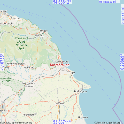
Scarborough GPS coordinates[2]
54° 16' 46.776" North, 0° 24' 15.948" West
| Map corner | latitude | longitude |
|---|---|---|
| Upper-left | 54.68812°, | -1.10755° |
| Center: | 54.27966°, | -0.40443° |
| Lower-right: | 53.86711°, | 0.29869° |
| Map W x H: | 91.3×91.3 km | = 56.7×56.7mi |
| max Lat: | 60.39635° ⇑19.3% North |
| Scarborough: | 54.27966° |
| min Lat: | ⇓80.7% South 34.60088° |
| min Long | Scarborough | max Long |
| -7.64133° | -0.40443° | 32.95536° |
| W 78.8%⇐ | ⇒21.2% E |
Elevation
Elevation of Scarborough is 48 m = 157 ft, and this is 24.9 m = 82 ft below average elevation for this country.
| Max E: |
515 m = 1690 ft | 59.1% |
| Avg. | 72.9 m = 239 ft | |
| Scarborough | 48 m = 157 ft | |
Min E: |
-30 m = -98 ft | 40.9% |
See also: Scarborough elevation on elevation.city.
Geographical zone
Scarborough is located in North temperate zone (between Tropic of Cancer and the Arctic Circle). Distance of this North polar circle is 1365.8 km =848.7 mi to North.| Distance of | km | miles | from Scarborough |
|---|---|---|---|
| North Pole | 3971.7 | 2467.9 | to North |
| Arctic Circle | 1365.8 | 848.7 | to North |
| Tropic Cancer | 3429.4 | 2130.9 | to South |
| Equator | 6035.3 | 3750.2 | to South |


Nearby cities:
15 places around Scarborough: (largest is in red/bold)
• Bempton
22.2 km =13.8 mi,  138°
138°
• Boynton
22.2 km =13.8 mi,  155°
155°
• Burniston
5.7 km =3.5 mi,  330°
330°
• Cloughton
7.1 km =4.4 mi,  336°
336°
• East Ayton
5.3 km =3.3 mi,  238°
238°
• Filey
10.8 km =6.7 mi, 135°
• Grindale
19.2 km =11.9 mi,  153°
153°
• Hunmanby
12.4 km =7.7 mi, 153°
• Rillington
23.2 km =14.4 mi,  234°
234°
• Snainton
13.2 km =8.2 mi, 243°
• Thornton Dale
21.1 km =13.1 mi,  256°
256°
• Thorpe Bassett
23.4 km =14.5 mi, 231°
• Thwing
18.3 km =11.4 mi,  176°
176°
• Wintringham
21.7 km =13.5 mi, 226°
• Wold Newton
15.2 km =9.4 mi, 178°
Sources, notices
• [Note1] Compared only with cities in United Kingdom existing in our database
• [Src1] Map data: © OpenStreetMap contributors (CC-BY-SA)
• [Src2] Other city data from geonames.org with taken over terms of usage.
• [Src3] Geographical zone / Annual Mean Temperature by Robert A. Rohde @ Wikipedia
