Saxlingham Nethergate geodata
Saxlingham Nethergate (England) is a populated place; located in United Kingdom in Europe/London (GMT+1) time zone. With population of 688 people, there are 4302 cities with bigger population in this country. Compared to other cities in United Kingdom, 50.8% of cities are located further ↓South; 98.3% of cities are located further ←West and 76.3% of cities have higher elevation than Saxlingham Nethergate. Note1
Administrative division(s):
- Level 1: England
- Level 2: Norfolk
- Level 3: South Norfolk District
- Level 4: Saxlingham Nethergate


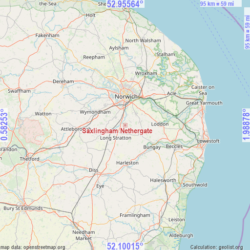
Saxlingham Nethergate GPS coordinates[2]
52° 31' 47.928" North, 1° 17' 8.34" East
| Map corner | latitude | longitude |
|---|---|---|
| Upper-left | 52.95564°, | 0.58253° |
| Center: | 52.52998°, | 1.28565° |
| Lower-right: | 52.10015°, | 1.98878° |
| Map W x H: | 95.1×95.1 km | = 59.1×59.1mi |
| max Lat: | 60.39635° ⇑49.2% North |
| Saxlingham Nethergate: | 52.52998° |
| min Lat: | ⇓50.8% South 34.60088° |
| min Long | Saxlingham Neth | max Long |
| -7.64133° | 1.28565° | 32.95536° |
| W 98.3%⇐ | ⇒1.7% E |
Elevation
Elevation of Saxlingham Nethergate is 25 m = 82 ft, and this is 47.9 m = 157 ft below average elevation for this country.
| Max E: |
515 m = 1690 ft | 76.3% |
| Avg. | 72.9 m = 239 ft | |
| Saxlingham Nethergate | 25 m = 82 ft | |
Min E: |
-30 m = -98 ft | 23.7% |
See also: United Kingdom elevation on elevation.city.
Geographical zone
Saxlingham Nethergate is located in North temperate zone (between Tropic of Cancer and the Arctic Circle). Distance of this North polar circle is 1560.4 km =969.6 mi to North.| Distance of | km | miles | from Saxlingham Nethergate |
|---|---|---|---|
| North Pole | 4166.3 | 2588.8 | to North |
| Arctic Circle | 1560.4 | 969.6 | to North |
| Tropic Cancer | 3234.9 | 2010.1 | to South |
| Equator | 5840.8 | 3629.3 | to South |


Nearby cities:
15 places around Saxlingham Nethergate: (largest is in red/bold)
• Alpington
7.7 km =4.8 mi,  57°
57°
• Brooke
5.9 km =3.7 mi,  77°
77°
• Cringleford
8.8 km =5.5 mi,  341°
341°
• Hellington
10.2 km =6.3 mi, 57°
• Hempnall
3.4 km =2.1 mi,  162°
162°
• Hethersett
10.7 km =6.6 mi,  314°
314°
• Long Stratton
5.8 km =3.6 mi,  216°
216°
• Mulbarton
4.8 km =3 mi, 312°
• Norwich
10.9 km =6.8 mi,  4°
4°
• Poringland
6 km =3.7 mi,  45°
45°
• Rockland Saint Mary
10.4 km =6.5 mi, 52°
• Stoke Holy Cross
4.5 km =2.8 mi,  7°
7°
• Swardeston
5.7 km =3.5 mi,  333°
333°
• Thurton
10.4 km =6.5 mi,  73°
73°
• Woodton
7.2 km =4.5 mi,  122°
122°
Sources, notices
• [Note1] Compared only with cities in United Kingdom existing in our database
• [Src1] Map data: © OpenStreetMap contributors (CC-BY-SA)
• [Src2] Other city data from geonames.org with taken over terms of usage.
• [Src3] Geographical zone / Annual Mean Temperature by Robert A. Rohde @ Wikipedia
