Sampford Peverell geodata
Sampford Peverell (England) is a populated place; located in United Kingdom in Europe/London (GMT+1) time zone. With population of 1,302 people, there are 3249 cities with bigger population in this country. Compared to other cities in United Kingdom, 92.8% of cities are located further ↑North; 80.5% of cities are located further →East and 69.8% of cities have lower elevation than Sampford Peverell. Note1
Administrative division(s):
- Level 1: England
- Level 2: Devon
- Level 3: Mid Devon District
- Level 4: Sampford Peverell


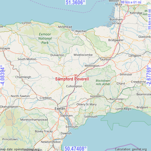
Sampford Peverell GPS coordinates[2]
50° 55' 10.02" North, 3° 22' 50.916" West
| Map corner | latitude | longitude |
|---|---|---|
| Upper-left | 51.3606°, | -4.08394° |
| Center: | 50.91945°, | -3.38081° |
| Lower-right: | 50.47408°, | -2.67769° |
| Map W x H: | 98.6×98.6 km | = 61.3×61.3mi |
| max Lat: | 60.39635° ⇑92.8% North |
| Sampford Peverell: | 50.91945° |
| min Lat: | ⇓7.2% South 34.60088° |
| min Long | Sampford Pevere | max Long |
| -7.64133° | -3.38081° | 32.95536° |
| W 19.5%⇐ | ⇒80.5% E |
Elevation
Elevation of Sampford Peverell is 95 m = 312 ft, and this is 22.1 m = 73 ft above average elevation for this country.
| Max E: |
515 m = 1690 ft | 30.2% |
| Sampford Peverell | 95 m 312 ft | |
| Avg. | 72.9 m = 239 ft | |
Min E: |
-30 m = -98 ft | 69.8% |
See also: United Kingdom elevation on elevation.city.
Geographical zone
Sampford Peverell is located in North temperate zone (between Tropic of Cancer and the Arctic Circle). Distance of this North polar circle is 1739.5 km =1080.9 mi to North.| Distance of | km | miles | from Sampford Peverell |
|---|---|---|---|
| North Pole | 4345.3 | 2700 | to North |
| Arctic Circle | 1739.5 | 1080.9 | to North |
| Tropic Cancer | 3055.8 | 1898.8 | to South |
| Equator | 5661.7 | 3518 | to South |


Nearby cities:
15 places around Sampford Peverell: (largest is in red/bold)
• Bickleigh
11.4 km =7.1 mi,  231°
231°
• Bradninch
11 km =6.8 mi,  196°
196°
• Cullompton
7.2 km =4.5 mi,  186°
186°
• Culmstock
7.2 km =4.5 mi,  94°
94°
• Dunkeswell
12.7 km =7.9 mi,  119°
119°
• Halberton
2.6 km =1.6 mi,  238°
238°
• Hemyock
10.7 km =6.6 mi, 94°
• Kentisbeare
7.2 km =4.5 mi,  147°
147°
• Langford Budville
11.7 km =7.3 mi,  42°
42°
• Milverton
14.6 km =9.1 mi, 37°
• Silverton
13.5 km =8.4 mi,  212°
212°
• Tiverton
8 km =5 mi,  256°
256°
• Uffculme
4 km =2.5 mi,  111°
111°
• Willand
4.1 km =2.5 mi,  166°
166°
• Wiveliscombe
14.4 km =8.9 mi,  19°
19°
Sources, notices
• [Note1] Compared only with cities in United Kingdom existing in our database
• [Src1] Map data: © OpenStreetMap contributors (CC-BY-SA)
• [Src2] Other city data from geonames.org with taken over terms of usage.
• [Src3] Geographical zone / Annual Mean Temperature by Robert A. Rohde @ Wikipedia
