Langford Budville geodata
Langford Budville (England) is a populated place; located in United Kingdom in Europe/London (GMT+1) time zone. With population of 535 people, there are 4785 cities with bigger population in this country. Compared to other cities in United Kingdom, 91.3% of cities are located further ↑North; 79.3% of cities are located further →East and 77.2% of cities have lower elevation than Langford Budville. Note1
Administrative division(s):
- Level 1: England
- Level 2: Somerset
- Level 3: Taunton Deane District
- Level 4: Langford Budville


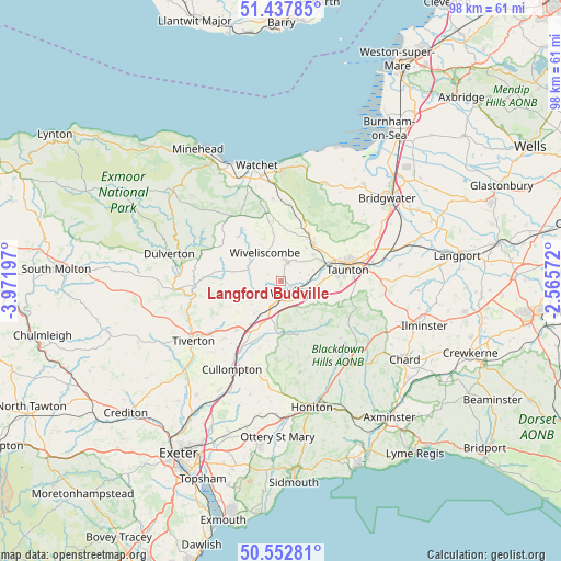
Langford Budville GPS coordinates[2]
50° 59' 50.784" North, 3° 16' 7.86" West
| Map corner | latitude | longitude |
|---|---|---|
| Upper-left | 51.43785°, | -3.97197° |
| Center: | 50.99744°, | -3.26885° |
| Lower-right: | 50.55281°, | -2.56572° |
| Map W x H: | 98.4×98.4 km | = 61.1×61.1mi |
| max Lat: | 60.39635° ⇑91.3% North |
| Langford Budville: | 50.99744° |
| min Lat: | ⇓8.7% South 34.60088° |
| min Long | Langford Budvil | max Long |
| -7.64133° | -3.26885° | 32.95536° |
| W 20.7%⇐ | ⇒79.3% E |
Elevation
Elevation of Langford Budville is 111 m = 364 ft, and this is 38.1 m = 125 ft above average elevation for this country.
| Max E: |
515 m = 1690 ft | 22.8% |
| Langford Budville | 111 m 364 ft | |
| Avg. | 72.9 m = 239 ft | |
Min E: |
-30 m = -98 ft | 77.2% |
See also: United Kingdom elevation on elevation.city.
Geographical zone
Langford Budville is located in North temperate zone (between Tropic of Cancer and the Arctic Circle). Distance of this North polar circle is 1730.8 km =1075.5 mi to North.| Distance of | km | miles | from Langford Budville |
|---|---|---|---|
| North Pole | 4336.7 | 2694.7 | to North |
| Arctic Circle | 1730.8 | 1075.5 | to North |
| Tropic Cancer | 3064.5 | 1904.2 | to South |
| Equator | 5670.4 | 3523.4 | to South |


Nearby cities:
15 places around Langford Budville: (largest is in red/bold)
• Bishops Lydeard
8.9 km =5.5 mi,  39°
39°
• Creech Saint Michael
16.4 km =10.2 mi,  79°
79°
• Cullompton
18 km =11.2 mi,  208°
208°
• Culmstock
9.3 km =5.8 mi,  184°
184°
• Dunkeswell
15.3 km =9.5 mi,  167°
167°
• Halberton
14.2 km =8.8 mi,  225°
225°
• Hemyock
9.9 km =6.2 mi,  163°
163°
• Henlade
15.9 km =9.9 mi, 84°
• Kentisbeare
15.2 km =9.4 mi,  194°
194°
• Milverton
3.1 km =1.9 mi,  22°
22°
• Sampford Peverell
11.7 km =7.3 mi,  222°
222°
• Taunton
11.8 km =7.3 mi, 80°
• Uffculme
11 km =6.8 mi,  201°
201°
• Willand
14.4 km =8.9 mi, 208°
• Wiveliscombe
5.8 km =3.6 mi,  327°
327°
Sources, notices
• [Note1] Compared only with cities in United Kingdom existing in our database
• [Src1] Map data: © OpenStreetMap contributors (CC-BY-SA)
• [Src2] Other city data from geonames.org with taken over terms of usage.
• [Src3] Geographical zone / Annual Mean Temperature by Robert A. Rohde @ Wikipedia
