Saltburn-by-the-Sea geodata
Saltburn-by-the-Sea (England) is a populated place; located in United Kingdom in Europe/London (GMT+1) time zone. With population of 5,958 people, there are 1469 cities with bigger population in this country. Compared to other cities in United Kingdom, 83% of cities are located further ↓South; 67.2% of cities are located further ←West and 55.9% of cities have higher elevation than Saltburn-by-the-Sea. Note1
Administrative division(s):
- Level 1: England
- Level 2: Redcar and Cleveland
- Level 3: Saltburn, Marske and New Marske


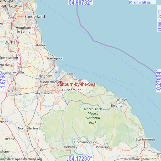
Saltburn-by-the-Sea GPS coordinates[2]
54° 34' 56.532" North, 0° 58' 25.212" West
| Map corner | latitude | longitude |
|---|---|---|
| Upper-left | 54.98782°, | -1.6768° |
| Center: | 54.58237°, | -0.97367° |
| Lower-right: | 54.17285°, | -0.27054° |
| Map W x H: | 90.6×90.6 km | = 56.3×56.3mi |
| max Lat: | 60.39635° ⇑17% North |
| Saltburn-by-the-Sea: | 54.58237° |
| min Lat: | ⇓83% South 34.60088° |
| min Long | Saltburn-by-the | max Long |
| -7.64133° | -0.97367° | 32.95536° |
| W 67.2%⇐ | ⇒32.8% E |
Elevation
Elevation of Saltburn-by-the-Sea is 52 m = 171 ft, and this is 20.9 m = 69 ft below average elevation for this country.
| Max E: |
515 m = 1690 ft | 55.9% |
| Avg. | 72.9 m = 239 ft | |
| Saltburn-by-the-Sea | 52 m = 171 ft | |
Min E: |
-30 m = -98 ft | 44.1% |
See also: United Kingdom elevation on elevation.city.
Geographical zone
Saltburn-by-the-Sea is located in North temperate zone (between Tropic of Cancer and the Arctic Circle). Distance of this North polar circle is 1332.2 km =827.8 mi to North.| Distance of | km | miles | from Saltburn-by-the-Sea |
|---|---|---|---|
| North Pole | 3938.1 | 2447 | to North |
| Arctic Circle | 1332.2 | 827.8 | to North |
| Tropic Cancer | 3463.1 | 2151.9 | to South |
| Equator | 6069 | 3771.1 | to South |


Nearby cities:
15 places around Saltburn-by-the-Sea: (largest is in red/bold)
• Boosbeck
4.4 km =2.7 mi,  186°
186°
• Brotton
2.8 km =1.7 mi,  128°
128°
• Danby
13.6 km =8.5 mi,  162°
162°
• Easington
8.6 km =5.3 mi,  112°
112°
• Guisborough
7.5 km =4.7 mi,  225°
225°
• Hinderwell
13.8 km =8.6 mi, 110°
• Lingdale
5 km =3.1 mi,  168°
168°
• Loftus
5.9 km =3.7 mi,  120°
120°
• Marske-by-the-Sea
3.1 km =1.9 mi,  288°
288°
• New Marske
4.4 km =2.7 mi,  264°
264°
• Redcar
6.7 km =4.2 mi,  304°
304°
• Skelton
2.6 km =1.6 mi,  201°
201°
• Skinningrove
5.1 km =3.2 mi, 107°
• South Bank
11.5 km =7.1 mi, 261°
• Staithes
12 km =7.5 mi,  102°
102°
Sources, notices
• [Note1] Compared only with cities in United Kingdom existing in our database
• [Src1] Map data: © OpenStreetMap contributors (CC-BY-SA)
• [Src2] Other city data from geonames.org with taken over terms of usage.
• [Src3] Geographical zone / Annual Mean Temperature by Robert A. Rohde @ Wikipedia
