Marske-by-the-Sea geodata
Marske-by-the-Sea (England) is a populated place; located in United Kingdom in Europe/London (GMT+1) time zone. With population of 8,282 people, there are 1197 cities with bigger population in this country. Compared to other cities in United Kingdom, 83% of cities are located further ↓South; 66.4% of cities are located further ←West and 79% of cities have higher elevation than Marske-by-the-Sea. Note1
Administrative division(s):
- Level 1: England
- Level 2: Redcar and Cleveland
- Level 3: Saltburn, Marske and New Marske


Marske-by-the-Sea GPS coordinates[2]
54° 35' 29.292" North, 1° 1' 10.524" West
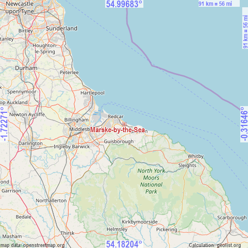
| Map corner | latitude | longitude |
|---|---|---|
| Upper-left | 54.99683°, | -1.72271° |
| Center: | 54.59147°, | -1.01959° |
| Lower-right: | 54.18204°, | -0.31646° |
| Map W x H: | 90.6×90.6 km | = 56.3×56.3mi |
| max Lat: | 60.39635° ⇑17% North |
| Marske-by-the-Sea: | 54.59147° |
| min Lat: | ⇓83% South 34.60088° |
| min Long | Marske-by-the-S | max Long |
| -7.64133° | -1.01959° | 32.95536° |
| W 66.4%⇐ | ⇒33.6% E |
Elevation
Elevation of Marske-by-the-Sea is 22 m = 72 ft, and this is 50.9 m = 167 ft below average elevation for this country.
| Max E: |
515 m = 1690 ft | 79% |
| Avg. | 72.9 m = 239 ft | |
| Marske-by-the-Sea | 22 m = 72 ft | |
Min E: |
-30 m = -98 ft | 21% |
See also: United Kingdom elevation on elevation.city.
Geographical zone
Marske-by-the-Sea is located in North temperate zone (between Tropic of Cancer and the Arctic Circle). Distance of this North polar circle is 1331.2 km =827.2 mi to North.| Distance of | km | miles | from Marske-by-the-Sea |
|---|---|---|---|
| North Pole | 3937.1 | 2446.4 | to North |
| Arctic Circle | 1331.2 | 827.2 | to North |
| Tropic Cancer | 3464.1 | 2152.5 | to South |
| Equator | 6070 | 3771.7 | to South |


Nearby cities:
15 places around Marske-by-the-Sea: (largest is in red/bold)
• Boosbeck
6 km =3.7 mi,  155°
155°
• Brotton
5.9 km =3.7 mi,  118°
118°
• Easington
11.7 km =7.3 mi,  111°
111°
• Great Ayton
13.4 km =8.3 mi,  214°
214°
• Guisborough
6.7 km =4.2 mi,  200°
200°
• Lingdale
7.1 km =4.4 mi,  146°
146°
• Loftus
9 km =5.6 mi, 116°
• Middlesbrough
14 km =8.7 mi,  263°
263°
• New Marske
2.1 km =1.3 mi,  225°
225°
• Nunthorpe
12.7 km =7.9 mi,  236°
236°
• Redcar
3.8 km =2.4 mi,  317°
317°
• Saltburn-by-the-Sea
3.1 km =1.9 mi, 108°
• Skelton
4 km =2.5 mi, 149°
• Skinningrove
8.2 km =5.1 mi, 107°
• South Bank
8.8 km =5.5 mi,  251°
251°
Sources, notices
• [Note1] Compared only with cities in United Kingdom existing in our database
• [Src1] Map data: © OpenStreetMap contributors (CC-BY-SA)
• [Src2] Other city data from geonames.org with taken over terms of usage.
• [Src3] Geographical zone / Annual Mean Temperature by Robert A. Rohde @ Wikipedia
