Rhondda geodata
Rhondda (Wales) is a populated place; located in United Kingdom in Europe/London (GMT+1) time zone. With population of 59,450 people, there are 189 cities with bigger population in this country. Compared to other cities in United Kingdom, 72.4% of cities are located further ↑North; 81.5% of cities are located further →East and 99.2% of cities have lower elevation than Rhondda. Note1


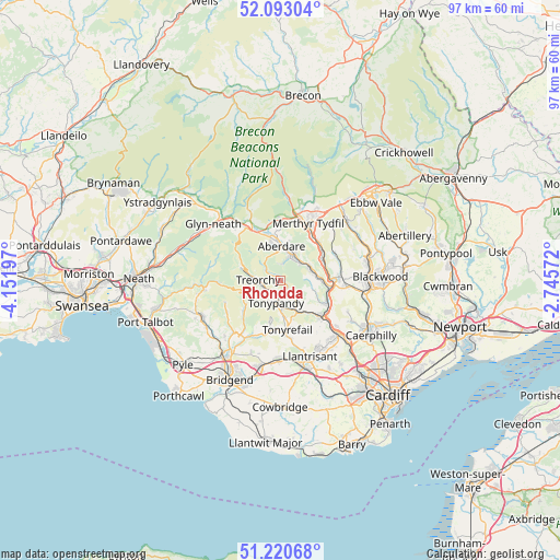
Rhondda GPS coordinates[2]
51° 39' 32.256" North, 3° 26' 55.86" West
| Map corner | latitude | longitude |
|---|---|---|
| Upper-left | 52.09304°, | -4.15197° |
| Center: | 51.65896°, | -3.44885° |
| Lower-right: | 51.22068°, | -2.74572° |
| Map W x H: | 97×97 km | = 60.3×60.3mi |
| max Lat: | 60.39635° ⇑72.4% North |
| Rhondda: | 51.65896° |
| min Lat: | ⇓27.6% South 34.60088° |
| min Long | Rhondda | max Long |
| -7.64133° | -3.44885° | 32.95536° |
| W 18.5%⇐ | ⇒81.5% E |
Elevation
Elevation of Rhondda is 256 m = 840 ft, and this is 183.1 m = 601 ft above average elevation for this country.
| Max E: |
515 m = 1690 ft | 0.8% |
| Rhondda | 256 m 840 ft | |
| Avg. | 72.9 m = 239 ft | |
Min E: |
-30 m = -98 ft | 99.2% |
See also: Rhondda elevation on elevation.city.
Geographical zone
Rhondda is located in North temperate zone (between Tropic of Cancer and the Arctic Circle). Distance of this North polar circle is 1657.2 km =1029.7 mi to North.| Distance of | km | miles | from Rhondda |
|---|---|---|---|
| North Pole | 4263.1 | 2649 | to North |
| Arctic Circle | 1657.2 | 1029.7 | to North |
| Tropic Cancer | 3138 | 1949.9 | to South |
| Equator | 5743.9 | 3569.1 | to South |


Nearby cities:
15 places around Rhondda: (largest is in red/bold)
• Aberdare
6.2 km =3.9 mi,  359°
359°
• Clydach Vale
4.2 km =2.6 mi,  211°
211°
• Cwmbach
5.9 km =3.7 mi,  27°
27°
• Ferndale
0.2 km =0.1 mi, 27°
• Gilfach Goch
7.6 km =4.7 mi,  192°
192°
• Llwynypia
2.9 km =1.8 mi,  181°
181°
• Maerdy
3.2 km =2 mi,  304°
304°
• Mountain Ash
5.5 km =3.4 mi,  59°
59°
• Pentre
3 km =1.9 mi,  259°
259°
• Porth
6 km =3.7 mi,  148°
148°
• Price Town
7.6 km =4.7 mi,  233°
233°
• Tonypandy
4.1 km =2.5 mi, 186°
• Treherbert
5.7 km =3.5 mi,  283°
283°
• Treorchy
3.9 km =2.4 mi,  271°
271°
• Ynysybwl
6.5 km =4 mi,  109°
109°
Sources, notices
• [Note1] Compared only with cities in United Kingdom existing in our database
• [Src1] Map data: © OpenStreetMap contributors (CC-BY-SA)
• [Src2] Other city data from geonames.org with taken over terms of usage.
• [Src3] Geographical zone / Annual Mean Temperature by Robert A. Rohde @ Wikipedia
