Redditch geodata
Redditch (England) is a populated place; located in United Kingdom in Europe/London (GMT+1) time zone. With population of 84,300 people, there are 119 cities with bigger population in this country. Compared to other cities in United Kingdom, 53.8% of cities are located further ↑North; 53.7% of cities are located further →East and 78.9% of cities have lower elevation than Redditch. Note1


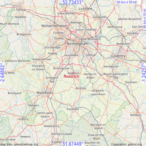
Redditch GPS coordinates[2]
52° 18' 23.4" North, 1° 56' 44.484" West
| Map corner | latitude | longitude |
|---|---|---|
| Upper-left | 52.73433°, | -2.64882° |
| Center: | 52.3065°, | -1.94569° |
| Lower-right: | 51.87449°, | -1.24257° |
| Map W x H: | 95.6×95.6 km | = 59.4×59.4mi |
| max Lat: | 60.39635° ⇑53.8% North |
| Redditch: | 52.3065° |
| min Lat: | ⇓46.2% South 34.60088° |
| min Long | Redditch | max Long |
| -7.64133° | -1.94569° | 32.95536° |
| W 46.3%⇐ | ⇒53.7% E |
Elevation
Elevation of Redditch is 115 m = 377 ft, and this is 42.1 m = 138 ft above average elevation for this country.
| Max E: |
515 m = 1690 ft | 21.1% |
| Redditch | 115 m 377 ft | |
| Avg. | 72.9 m = 239 ft | |
Min E: |
-30 m = -98 ft | 78.9% |
See also: Redditch elevation on elevation.city.
Geographical zone
Redditch is located in North temperate zone (between Tropic of Cancer and the Arctic Circle). Distance of this North polar circle is 1585.2 km =985 mi to North.| Distance of | km | miles | from Redditch |
|---|---|---|---|
| North Pole | 4191.1 | 2604.2 | to North |
| Arctic Circle | 1585.2 | 985 | to North |
| Tropic Cancer | 3210 | 1994.6 | to South |
| Equator | 5815.9 | 3613.8 | to South |


Nearby cities:
15 places around Redditch: (largest is in red/bold)
• Alcester
11.3 km =7 mi,  151°
151°
• Alvechurch
5.2 km =3.2 mi,  345°
345°
• Astwood Bank
5.2 km =3.2 mi,  173°
173°
• Barnt Green
7.2 km =4.5 mi,  324°
324°
• Beoley
3.9 km =2.4 mi,  60°
60°
• Bromsgrove
8.4 km =5.2 mi,  292°
292°
• Dickens Heath
11.4 km =7.1 mi,  39°
39°
• Earlswood
10.1 km =6.3 mi,  49°
49°
• Henley in Arden
11.5 km =7.1 mi,  98°
98°
• Hopwood
7.2 km =4.5 mi, 353°
• Inkberrow
10.7 km =6.6 mi,  192°
192°
• Stoke Prior
9.2 km =5.7 mi,  265°
265°
• Studley
5.4 km =3.4 mi,  137°
137°
• Tidbury Green
10.3 km =6.4 mi, 36°
• Wychbold
11.7 km =7.3 mi,  261°
261°
Sources, notices
• [Note1] Compared only with cities in United Kingdom existing in our database
• [Src1] Map data: © OpenStreetMap contributors (CC-BY-SA)
• [Src2] Other city data from geonames.org with taken over terms of usage.
• [Src3] Geographical zone / Annual Mean Temperature by Robert A. Rohde @ Wikipedia
